Conneautville, Pennsylvania facts for kids
Quick facts for kids
Conneautville, Pennsylvania
|
|
|---|---|
|
Borough
|
|

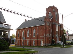
Valley Church
|
|
| Etymology: Conneautee, Seneca word | |

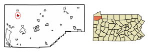
Location of Conneautville in Crawford County, Pennsylvania.
|
|
| Country | United States |
| State | Pennsylvania |
| County | Crawford |
| Founded | 1843 |
| Area | |
| • Total | 1.12 sq mi (2.90 km2) |
| • Land | 1.11 sq mi (2.88 km2) |
| • Water | 0.01 sq mi (0.01 km2) |
| Elevation
(middle of borough)
|
949 ft (289 m) |
| Highest elevation
(east side of borough)
|
1,100 ft (300 m) |
| Lowest elevation
(Conneaut Creek)
|
920 ft (280 m) |
| Population
(2020)
|
|
| • Total | 736 |
| • Estimate
(2022)
|
729 |
| • Density | 663.97/sq mi (256.47/km2) |
| Time zone | UTC-4 (EST) |
| • Summer (DST) | UTC-5 (EDT) |
| ZIP code |
16406
|
| Area code(s) | 814 |
Conneautville is a small town, also called a borough, in Crawford County, Pennsylvania, United States. It's located right next to Conneaut Creek. In 2020, about 736 people lived there.
Contents
Discovering Conneautville
A Look Back: History
Conneautville was started in 1814 by a person named Alexander Power. He was a surveyor and engineer. At first, the town was sometimes called "Powerstown" or "Power's Tract."
Alexander Power wanted the town to be named "Conneautville." This name comes from the Seneca word Conneaut or Conneautee. One meaning of this word is "Snow Place."
Where is Conneautville?
Conneautville is in the northwestern part of Crawford County. It sits in a valley near Conneaut Creek, which flows towards Lake Erie. The town is surrounded by other areas called Spring Township to the north and Summerhill Township to the south.
You can find Pennsylvania Route 18 running through the middle of Conneautville. This road goes north about 10 miles (16 km) to Albion and south about 11 miles (18 km) to Conneaut Lake. Another road, Pennsylvania Route 198, goes west from Conneautville about 8 miles (13 km) to the Ohio border and east about 9 miles (14 km) to Interstate 79 near Saegertown.
The United States Census Bureau says that Conneautville covers a total area of about 1.1 square miles (2.9 km²). Most of this area is land, with a very small part (about 0.01 square miles or 0.03 km²) being water.
Who Lives in Conneautville?
| Historical population | |||
|---|---|---|---|
| Census | Pop. | %± | |
| 1850 | 787 | — | |
| 1860 | 964 | 22.5% | |
| 1870 | 1,000 | 3.7% | |
| 1880 | 941 | −5.9% | |
| 1890 | 757 | −19.6% | |
| 1900 | 920 | 21.5% | |
| 1910 | 867 | −5.8% | |
| 1920 | 969 | 11.8% | |
| 1930 | 927 | −4.3% | |
| 1940 | 965 | 4.1% | |
| 1950 | 1,177 | 22.0% | |
| 1960 | 1,100 | −6.5% | |
| 1970 | 1,032 | −6.2% | |
| 1980 | 971 | −5.9% | |
| 1990 | 822 | −15.3% | |
| 2000 | 848 | 3.2% | |
| 2010 | 774 | −8.7% | |
| 2020 | 736 | −4.9% | |
| 2022 (est.) | 729 | −5.8% | |
| Sources: | |||
In 2000, there were 848 people living in Conneautville. The population has changed over the years, as you can see in the chart. By 2020, the population was 736 people.
Most households in Conneautville are families. About 30% of households had children under 18 living with them. The average household had about 2.4 people.
The median age of people in the borough was 40 years old. This means half the people were younger than 40 and half were older. About 24.6% of the population was under 18 years old.
Notable People from Conneautville
- Effie Louise Power (1873–1969) was born in Conneautville. She was a special librarian for children, a teacher, an author, and a storyteller.
See also
 In Spanish: Conneautville para niños


