Saegertown, Pennsylvania facts for kids
Quick facts for kids
Saegertown, Pennsylvania
|
|||
|---|---|---|---|
|
Borough
|
|||

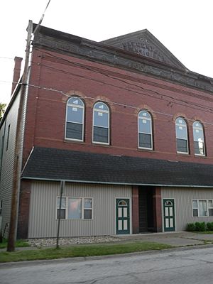
A street in Saegertown
|
|||
|
|||

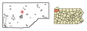
Location of Saegertown in Crawford County, Pennsylvania (left) and of Crawford County in Pennsylvania
|
|||
| Country | United States | ||
| State | Pennsylvania | ||
| County | Crawford | ||
| Founded | 1824 | ||
| Area | |||
| • Total | 1.45 sq mi (3.74 km2) | ||
| • Land | 1.45 sq mi (3.74 km2) | ||
| • Water | 0.00 sq mi (0.00 km2) | ||
| Elevation
(middle of borough)
|
1,115 ft (340 m) | ||
| Highest elevation
(east side of borough)
|
1,330 ft (410 m) | ||
| Lowest elevation | 1,100 ft (300 m) | ||
| Population
(2020)
|
|||
| • Total | 869 | ||
| • Density | 602.77/sq mi (232.73/km2) | ||
| Time zone | UTC-4 (EST) | ||
| • Summer (DST) | UTC-5 (EDT) | ||
| ZIP code |
16433
|
||
| Area code(s) | 814 | ||
Saegertown is a small town, called a borough, located in Crawford County, Pennsylvania. In 2020, about 869 people lived there. The town was started in 1824.
Contents
History of Saegertown
Saegertown began around 1795 when two brothers, Arthur and Patrick McGill, arrived in the area. Later, around 1800, Major Roger Alden built a sawmill. For a while, the settlement was known as Aldens Mill.
In 1824, a man named Daniel Saeger bought Alden's mill and the land around it. He was 44 years old and decided to plan out the town, giving it its current name. Daniel Saeger came from Egypt, Pennsylvania, in 1823, looking for a good place to settle. He was from a German family.
Saeger encouraged many other German families from eastern Pennsylvania to move to the area. He was an important part of the community. He helped start the Lutheran Church, owned a sawmill and a general store, and worked as a justice of the peace. He also served in the Pennsylvania State Legislature.
The Edward Saeger House, an important old building, was added to the National Register of Historic Places in 1980.
Geography and Location
Saegertown is located north of the center of Crawford County. Its exact location is 41°43′10″N 80°8′44″W / 41.71944°N 80.14556°W.
The borough is surrounded by Woodcock Township on its north, east, and south sides. To the west, across French Creek, is Hayfield Township.
Two major roads, U.S. Route 19 and U.S. Route 6, run through the middle of Saegertown. These roads lead northeast about 8 miles to Cambridge Springs and south about 6 miles to Meadville, which is the main town of Crawford County.
Pennsylvania Route 198 goes southeast about 6 miles to Blooming Valley. It also goes west about 3 miles to Exit 154 on Interstate 79. Using Interstate 79, you can travel about 32 miles north to Erie or about 95 miles south to Pittsburgh.
According to the United States Census Bureau, Saegertown covers a total area of about 4.0 square kilometers (1.45 square miles), and all of it is land.
Population Information
| Historical population | |||
|---|---|---|---|
| Census | Pop. | %± | |
| 1860 | 352 | — | |
| 1870 | 441 | 25.3% | |
| 1880 | 678 | 53.7% | |
| 1890 | 745 | 9.9% | |
| 1900 | 607 | −18.5% | |
| 1910 | 712 | 17.3% | |
| 1920 | 659 | −7.4% | |
| 1930 | 645 | −2.1% | |
| 1940 | 753 | 16.7% | |
| 1950 | 836 | 11.0% | |
| 1960 | 1,131 | 35.3% | |
| 1970 | 1,348 | 19.2% | |
| 1980 | 942 | −30.1% | |
| 1990 | 1,066 | 13.2% | |
| 2000 | 1,071 | 0.5% | |
| 2010 | 997 | −6.9% | |
| 2020 | 869 | −12.8% | |
| 2022 (est.) | 859 | −13.8% | |
| U.S. Decennial Census | |||
As of the census in 2000, there were 1,071 people living in Saegertown. There were 361 households, and 251 of them were families.
About 32.7% of households had children under 18 living with them. Many households were married couples living together. The average household had about 2.45 people.
The population included people of different ages. About 20.5% were under 18 years old. The median age was 36 years.
Notable People from Saegertown
Some well-known people have connections to Saegertown:
- Doug McKalip – He is a top negotiator for agriculture.
- Andrew Ryan McGill – He was the 10th governor of Minnesota.
- Sharon Stone – A famous actress.
- Melanie Tem – An author who wrote horror and fantasy stories.
- Spencer Lee – An Olympic wrestler.
See also

- In Spanish: Saegertown para niños
 | Leon Lynch |
 | Milton P. Webster |
 | Ferdinand Smith |


