
Cook Island (New South Wales) facts for kids
|
Native name:
Joong-urra-narrian
|
|
|---|---|
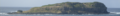
.jpg)
Aerial view of Cook Island and Fingal Head, New South Wales
|
|

Cook Island
Location in New South Wales
|
|
| Etymology | James Cook |
| Geography | |
| Location | Coral Sea |
| Coordinates | 28°11′54″S 153°35′04″E / 28.19833°S 153.58444°E |
| Area | 4.6 ha (11 acres) |
| Highest elevation | 24.8 m (81.4 ft) |
| Administration | |
| state | New South Wales |
| Local government area | Tweed Shire |
| Demographics | |
| Population | 0 |
| Additional information | |
| Time zone | |
| • Summer (DST) | |
Cook Island is a small island off the coast of New South Wales, Australia. It is located about 600 metres (2,000 ft) north-east of Fingal Head. The island is also about 4 kilometres (2.5 mi) south-east of the town of Tweed Heads. It has been known by other names, including Cooks Island, Turtle Island, and Joong-urra-narrian.
About Cook Island
How Cook Island Formed
Cook Island was created from ancient lava flows. These flows came from the Mount Warning Shield Volcano about 20 million years ago. The island is mostly made of hard rock called basalt. It rises about 24.8 metres (81 ft) above the sea. The top of the island is flat like a plateau. One side has a gentle slope, but the other sides are steep cliffs. There is also a small freshwater pool on the northern side.
Weather on the Island
In 2011, the island received about 1,470 millimetres (58 in) of rain each year. This is the average amount of rainfall.
Visiting the Island
It is not easy to get to Cook Island. The coastline is very rocky and the sea can be rough. Also, visitors are not encouraged to land on the island. This is to protect the many birds that rest and nest there. Their nests are fragile and can be easily damaged by people walking around.
Plants and Animals
Island Plants
In 2011, scientists found 25 different types of native plants on Cook Island. These plants grow in three main areas. Some grow in high places, others in rocky cracks, and some near the bottom of the cliffs.
Island Animals
Cook Island is home to many animals. In 2011, 25 types of birds and two types of reptiles lived there. Twelve of these bird species are migratory, meaning they travel long distances. Seven of the animal species are considered threatened in New South Wales. This means they need special protection to survive.
Island History
Aboriginal Stories
Cook Island is in the traditional lands of the Minjungbal people. They are part of the Bundjalung nation. Other Aboriginal groups, like the Githabul and Yugambeh people, also have special knowledge about the island. The Coodjinburra clan of the Bundjalung people call the island Joongurra-Narrian. This name means "the place of pelicans." Aboriginal people have many important stories and sites connected to the island.
European Explorers


The first European to see Cook Island was James Cook in 1770. He was an English navigator. Cook mapped the coastline but did not try to land on the island. He then sailed north and named nearby places like Mount Warning and Point Danger. He named them after almost crashing his ship there.
In 1823, another English explorer, John Oxley, stopped at the island. He was seeking shelter from strong winds. Two of his crew members visited the island. They found sea turtles and an old shipwreck. They named the island Turtle Island. Five years later, in 1828, British admiral Henry John Rous explored the Tweed River. He named the island Cook's Isle, which is similar to its current name.
In 1970, the island's name was officially changed to Cook Island.
Protecting Cook Island
Cook Island has been a protected area since 1959. Since 1967, it has been part of the Cook Island Nature Reserve. This means the island's plants and animals are protected. The waters around the island are also protected. Since 1998, they have been part of the Cook Island Aquatic Reserve. This helps protect the marine life, like fish and corals, around the island.
Images for kids
-
Panorama of Cook Island, in 2009, from Fingal Head
