Cooksville Creek facts for kids
Quick facts for kids Cooksville Creek |
|
|---|---|

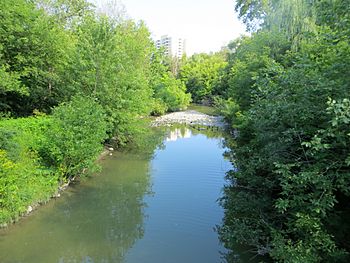
Looking downstream from a pedestrian bridge just downstream of The Queensway
|
|
|
Location of the mouth of Cooksville Creek in southern Ontario
|
|
| Country | Canada |
| Province | Ontario |
| Region | Greater Toronto Area |
| Regional Municipality | Peel |
| Municipality | Mississauga |
| Physical characteristics | |
| Main source | 183 m (600 ft) 43°37′35″N 79°40′58″W / 43.62639°N 79.68278°W |
| River mouth | Lake Ontario 74 m (243 ft) 43°33′53″N 79°33′55″W / 43.56472°N 79.56528°W |
| Length | 16 km (9.9 mi) |
| Basin features | |
| River system | Great Lakes Basin |
| Basin size | 33.9 km2 (13.1 sq mi) |
Cooksville Creek is a small stream located in Mississauga, Ontario, Canada. It flows through the Regional Municipality of Peel in the Greater Toronto Area. This creek is an important natural feature in the city.
Contents
Where Cooksville Creek Starts and Ends
Cooksville Creek begins its journey near Bristol Road West and Hurontario Street. From there, it flows south through the city. Its path eventually leads it to empty into Lake Ontario. The mouth of the creek is found at R.K. McMilian Park, close to Lakeshore Road and Cawthra Road.
The Community of Cooksville
The community of Cooksville is named after the creek. This area is situated on the west side of the creek. You can find the community near the intersection of Hurontario Street and Dundas Street East.
What's Around the Creek?
Cooksville Creek mostly flows through areas with many homes. These are called residential areas. Along its path, the creek also passes by several green spaces and parks. These parks offer places for people to relax and enjoy nature.
Parks Along Cooksville Creek
Here are some of the parks located near Cooksville Creek:
- R.K. McMilian Park
- Camilla Park
- Cooksville Park
- R. Jones Park
- Mississauga Valley Park
- Stonebrook Park
- Woodington Green
- Kingsbridge Common
Understanding the Creek's Drainage Basin
Every creek or river has a drainage basin. This is the area of land where all the rain and melted snow eventually flow into that specific body of water. For Cooksville Creek, its drainage basin is quite large.
Size and Purpose of the Basin
The Cooksville Creek drainage basin stretches for about 16 kilometres (9.9 mi). It is roughly 2 kilometres (1.2 mi) wide. The total area of this basin is about 33.9 square kilometres (13.1 sq mi). This basin helps to collect extra water from storm sewers. Storm sewers are underground pipes that carry rainwater away from streets and buildings.
Urban Development in the Basin
Most of the Cooksville Creek drainage basin is developed. About 94% of the land is covered by buildings, roads, and other structures. Only a small part, about 6%, remains as open, natural space. This shows how much the area around the creek has been built up over time.


