
Coolabah, New South Wales facts for kids
Quick facts for kids CoolabahNew South Wales |
|
|---|---|

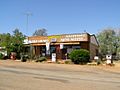
Post office and petrol station, 2007
|
|

Coolabah
Location in New South Wales
|
|
| Population | 69 (2016 census) |
| Postcode(s) | 2831 |
| Location | |
| LGA(s) |
|
| Region | Orana |
| County | Canbelego |
| Parish | Vega |
| State electorate(s) | Barwon |
| Federal Division(s) | Parkes |
Coolabah is a small village located in the western part of New South Wales, Australia. It's about 76 kilometers (around 47 miles) north of a town called Nyngan. If you were traveling from Sydney, Australia's largest city, Coolabah is about 656 kilometers (around 407 miles) to the north-west.
The village is interesting because it sits on both sides of the Mitchell Highway. This means that the area to the east of the highway is in one local government area, the Brewarrina Shire. The area to the west of the highway is in another, the Bogan Shire.
Contents
Coolabah: A Small Outback Village
Coolabah is a tiny community in the Australian outback. In 2016, only 69 people lived there. It's a quiet place, far from big cities.
Where is Coolabah?
Coolabah is in the Orana region of New South Wales. This region is known for its wide open spaces. The village is also part of two different local government areas. These are the Bogan Shire and the Brewarrina Shire.
A Glimpse into Coolabah's Past
The name "Coolabah" comes from a nearby property. This is a common way for places in Australia to get their names.
The Railway's Story
A very important part of Coolabah's history is its railway. The railway line opened in 1884. This was the main reason the village existed. It helped people and goods travel.
However, the railway line closed on May 17, 1989. This happened because of a big flood in nearby Nyngan. The flood caused a lot of damage, and the railway could no longer operate.
Images for kids
-
Petrol station, 2007
-
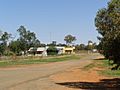
Streetscape of Mitchell Highway Service Road, 2007
-
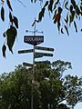
Distances from Coolabah, 2007


