Cope, Colorado facts for kids
Quick facts for kids
Cope, Colorado
|
|
|---|---|

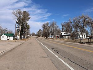
U.S. Route 36 in Cope.
|
|
| Country | |
| State | |
| County | Washington County |
| Government | |
| • Type | unincorporated town |
| Area | |
| • Total | 1.827 sq mi (4.731 km2) |
| • Land | 1.796 sq mi (4.651 km2) |
| • Water | 0.031 sq mi (0.080 km2) |
| Elevation | 4,429 ft (1,350 m) |
| Population
(2020)
|
|
| • Total | 53 |
| • Density | 29.01/sq mi (11.20/km2) |
| Time zone | UTC-7 (MST) |
| • Summer (DST) | UTC-6 (MDT) |
| ZIP Code |
80812
|
| Area code(s) | 970 |
| GNIS feature | Cope CDP |
Cope is a small, unincorporated town in Washington County, Colorado, United States. This means it's not officially a city or a village, but it's still a recognized community. It has its own post office and is counted as a special place by the government for population surveys.
Contents
Discovering Cope, Colorado
Cope is located in the eastern part of Colorado. It's a quiet place where people live and work. Even though it's small, it's an important part of Washington County.
The Story Behind Cope's Name
The history of Cope goes back many years. The town's post office first opened its doors in 1889. Cope was named after a person named Johnathon C. Cope. He was an important official who worked for the railroad.
Where is Cope?
Cope covers a small area of land. The total area is about 1,169 acres (4.731 km2). This includes a very small amount of water, which is about 20 acres (0.080 km2). It's a flat area, typical of eastern Colorado.
How Many People Live in Cope?
The United States Census Bureau counts how many people live in different places. This helps us understand communities better.
| Cope CDP, Colorado Population | ||
|---|---|---|
| Year | Pop. | ±% |
| 2020 | 53 | — |
| Source: United States Census Bureau | ||
The latest count was done in 2020. At that time, 53 people lived in the Cope area.
 | Mary Eliza Mahoney |
 | Susie King Taylor |
 | Ida Gray |
 | Eliza Ann Grier |


