Cornwall Island (Antarctica) facts for kids

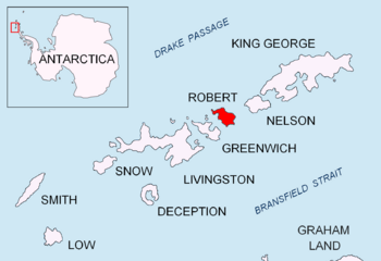
Location of Robert Island in the South Shetland Islands
|
|
|
Location of Cornwall Island
|
|
| Geography | |
|---|---|
| Location | Antarctica |
| Coordinates | 62°20′33.4″S 59°42′32.4″W / 62.342611°S 59.709000°W |
| Archipelago | South Shetland Islands |
| Area | 15 ha (37 acres) |
| Administration | |
| Administered under the Antarctic Treaty System | |
| Demographics | |
| Population | Uninhabited |
Cornwall Island is a small, ice-free island located near the coast of Robert Island in Antarctica. It is part of the South Shetland Islands. This island covers an area of about 15 hectares, which is roughly the size of 15 rugby fields.
Close to Cornwall Island, you'll find a rock called Mónica Rock. It lies about 1.65 kilometers (1 mile) west of the island. Long ago, in the early 1800s, people who hunted seals visited this area. They often worked from a nearby place called Clothier Harbour.
Why is it called Cornwall Island?
Cornwall Island got its name in 1935. A group called the Discovery Investigations named it. They were explorers who mapped and studied the Antarctic region. The island was named after Cornwall House. This was the building where the United Kingdom Hydrographic Office was located at the time. The Hydrographic Office is a place that makes maps and charts for ships.
Mónica Rock was mapped later, in 1949-50. This was done by a Chilean expedition exploring Antarctica. They named the rock after the oldest daughter of First Lieutenant Venturini. He was an important member of that expedition.
Where to find Cornwall Island
Cornwall Island is located at these coordinates: 62°20′33.4″S 59°42′32.4″W / 62.342611°S 59.709000°W. It is situated about 2.8 kilometers (1.7 miles) north of Fort William on Robert Island.
The island is also about 4.2 kilometers (2.6 miles) east of Table Island. You can find Rogozen Island about 920 meters (1,000 yards) to its south-southwest. Hammer Point on Robert Island is about 2.64 kilometers (1.6 miles) to the west. Many countries have mapped this area over the years, including Britain, Russia, France, Argentina, Chile, and Bulgaria.
 | Calvin Brent |
 | Walter T. Bailey |
 | Martha Cassell Thompson |
 | Alberta Jeannette Cassell |


