
Corstorphine Hill facts for kids
Quick facts for kids Corstorphine Hill |
|
|---|---|

Looking across Ravelston Golf Course to Corstorphine Hill
|
|
| Highest point | |
| Elevation | 161 m (528 ft) |
| Dimensions | |
| Length | 2.4 km (1.5 mi) N-S |
| Geography | |
|
Lua error in Module:Location_map at line 420: attempt to index field 'wikibase' (a nil value).
|
|
| OS grid | NT206738 |
| Topo map | Ordnance Survey Landranger 66 |
| Climbing | |
| Easiest route | Easy walk on well-defined paths from Ravelston Dykes Road or Clermiston Road |
Corstorphine Hill is a cool, low hill in western Edinburgh, Scotland. Even though there are homes and shops on its lower parts, most of the hill is a special nature reserve. It's full of trees and open for everyone to explore! This hill is mostly made of a hard rock called dolerite. It was shaped by huge glaciers moving across the land long, long ago. People have lived here since prehistoric times. Today, the hill is a popular spot for walking, jogging, and taking dogs for a stroll. You can also find a tower from the 1800s, a beautiful walled garden, and even a secret Cold War bunker!
Contents
Where is Corstorphine Hill?
Corstorphine Hill is about 5 kilometres (3 miles) west of Edinburgh's city centre. It's surrounded by different neighbourhoods. To the north, you'll find Barnton and Davidson's Mains. To the east are Blackhall and Murrayfield. Corstorphine is to the south, and Clermiston is to the west.
What Makes Corstorphine Hill Special?
The hill is a noticeable part of Edinburgh's landscape. It looks like a long, L-shaped ridge, stretching about 2.4 kilometres (1.5 miles) from north to south. Its highest point is 161 metres (528 feet) tall. The top parts of the hill are covered in trees and form a local nature reserve. This reserve is managed by the City of Edinburgh and a group called the Friends of Corstorphine Hill. It's the biggest urban woodland in the city!
Some parts of the lower hill have buildings on them. For example, there are homes, schools, and even two large hotels. Edinburgh Zoo also takes up a big area on the southern slopes. Corstorphine Hill is one of Edinburgh's traditional "Seven Hills". This name comes from the famous Seven Hills of Rome. It's the fourth highest of Edinburgh's seven hills.
Trees and Woodlands
The nature reserve has three main types of woodlands. There are about 15 acres of oak and birch trees. Sycamore and beech trees have also been planted here. You can also find about 21 acres of mixed woodland. These woods have native trees like ash, oak, and elm. Other trees like sycamore, lime, and various conifers have also been added. Finally, there are about 11 acres of more formal woodlands. These were once part of large estates and have many different kinds of trees.
Ancient Discoveries
People have found signs of very old settlements on Corstorphine Hill. In the late 1800s, workers digging in quarries found shells, bones, stone tools, and pottery. Other discoveries include hammer stones and pieces of pottery from ancient rubbish heaps. There are also eleven special "cup-marks" carved into rocks on the western slopes. Nine of these marks are in a pentagon shape, with two in the middle. These carvings were likely part of a sacred site from the Stone Age or Bronze Age. We don't know their exact purpose, but they are very old!
How the Hill Was Formed
Corstorphine Hill is mostly made of a hard, crystalline rock called dolerite. This rock sits on top of softer, more easily worn-away rocks. The hill was shaped by huge glaciers that moved from west to east during the Ice Age. This movement created steep cliffs of dolerite rock on the west side. It also left gentle slopes of clay and boulders on the east side. The top surface of the dolerite rock shows grooves. These grooves were cut by stones stuck in the bottom of the ice, like sandpaper scraping the surface!
Cool Places to See

- Corstorphine Hill Tower: This tower is also known as Clermiston Tower or the Scott Tower. It's near the top of the hill. A man named William Macfie built it in 1871. He built it to celebrate 100 years since the birth of the famous writer, Sir Walter Scott. In 1932, it was given to the city to mark 100 years since Scott's death. It's a five-storey tower with a square shape and castle-like tops.
- Walled Garden: This 1.2-acre garden is on the western slopes of the hill. It used to belong to Hillwood House. The city has owned it since 1927. It was once overgrown, but volunteers have worked hard to restore it. It was even shown on a TV show called The Beechgrove Garden in 2001 and 2004!
- Corstorphine Hill Cemetery: This cemetery is on Drum Brae, on the west side of the hill. It opened in 1928. The city took over its ownership in 1994. It has 35 graves of soldiers from the Commonwealth and 165 graves of Polish soldiers from World War II.
- Barnton Quarry: This used to be a stone quarry, but it closed in 1914. Now, it holds a secret! There's a three-floor deep underground bunker here. It was built in the 1950s to be a command centre in case of a nuclear war. The site was closed in 1983. After that, it was damaged by vandals and fire. Since 2011, volunteers have been fixing up the bunker. They hope to open it to visitors soon!
- Radio Masts: You can see two tall radio masts near the summit of the hill.
Fun Things to Do on the Hill
The nature reserve is a popular place for many outdoor activities. People love to walk, jog, take their dogs for walks, watch birds, and even go sledging in winter. The many trees limit the view from most of the hill. However, from the very top, you can see far in every direction! Since 2010, the hill has won a Green Flag Award. This award recognises it as a high-quality open space.
The hill also has a permanent orienteering course. This is a sport where you use a map and compass to find your way. The 215-kilometre (134-mile) John Muir Way long-distance path crosses the hill. This path goes between South Queensferry and Edinburgh. Corstorphine Hill is also part of the Seven Hills of Edinburgh race. This is an annual running race that goes over the city's traditional "seven hills." The race started in 1980 and usually happens on a Sunday in June.
There are also two golf courses on the eastern side of the hill: Ravelston Golf Course and Murrayfield Golf Course.
Images for kids
-
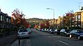
Corstorphine Hill, seen in the south from a residential street in the Balgreen area
-
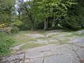
Glacial pavements on Corstorphine Hill, showing striation
-
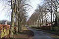
The avenue of trees leading to Corstorphine Hill Cemetery
-
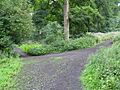
A path on Corstorphine Hill
-
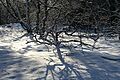
Corstorphine Hill in winter
-
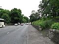
Entrance from Queensferry Road
-
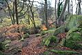
Woodland and rock formations


_-_geograph.org.uk_-_1400534.jpg)

