Corwith, Iowa facts for kids
Quick facts for kids
Corwith, Iowa
|
|
|---|---|

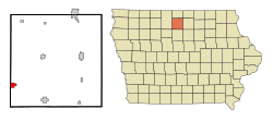
Location of Corwith, Iowa
|
|
| Country | |
| State | |
| County | Hancock |
| Area | |
| • Total | 1.45 sq mi (3.75 km2) |
| • Land | 1.45 sq mi (3.75 km2) |
| • Water | 0.00 sq mi (0.00 km2) |
| Elevation | 1,178 ft (359 m) |
| Population
(2020)
|
|
| • Total | 266 |
| • Density | 183.70/sq mi (70.91/km2) |
| Time zone | UTC-6 (Central (CST)) |
| • Summer (DST) | UTC-5 (CDT) |
| ZIP code |
50430
|
| Area code(s) | 515 |
| FIPS code | 19-16590 |
| GNIS feature ID | 0455640 |
Corwith is a small city in Hancock County, Iowa, United States. It is located in the state of Iowa, which is in the central part of the USA. As of the 2020 census, 266 people lived in Corwith.
Contents
History of Corwith
Corwith began in the year 1880. This happened after the Minneapolis & St. Louis Railroad built its tracks through the area. The very first buildings constructed in Corwith were a hotel and the train station. The town also experienced a fire in the 1800s.
Geography of Corwith
Corwith is located at specific coordinates (42.993334, -93.955931). It is found near the Boone River.
According to the United States Census Bureau, the city covers a total area of about 1.48 square miles (3.75 square kilometers). All of this area is land, meaning there are no large lakes or rivers within the city limits.
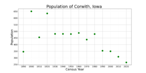
Population Information
| Historical populations | ||
|---|---|---|
| Year | Pop. | ±% |
| 1890 | 347 | — |
| 1900 | 651 | +87.6% |
| 1910 | 455 | −30.1% |
| 1920 | 635 | +39.6% |
| 1930 | 481 | −24.3% |
| 1940 | 481 | +0.0% |
| 1950 | 480 | −0.2% |
| 1960 | 488 | +1.7% |
| 1970 | 438 | −10.2% |
| 1980 | 480 | +9.6% |
| 1990 | 354 | −26.2% |
| 2000 | 350 | −1.1% |
| 2010 | 309 | −11.7% |
| 2020 | 266 | −13.9% |
| Source: and Iowa Data Center Source: |
||
A census is an official count of the population. It helps us understand how many people live in a place and what they are like.
2020 Census Details
In 2020, the census showed that 266 people lived in Corwith. There were 121 households and 75 families. The city had about 183.7 people per square mile.
Most of the people (88.7%) were White. About 1.5% were Black or African American, and 0.8% were Native American. About 13.5% of the population were Hispanic or Latino.
About 24% of households had children under 18 living with them. The average age in Corwith was 47.0 years old. About 20.7% of residents were under 20 years old.
2010 Census Details
The 2010 census counted 309 people living in Corwith. There were 141 households and 78 families. The population density was about 208.8 people per square mile.
In 2010, 97.7% of the people were White. About 4.2% of the population identified as Hispanic or Latino.
About 22% of households had children under 18. The average age was 46.3 years. About 20.1% of residents were under 18 years old.
Education in Corwith
The main school district for the Corwith area is the Algona Community School District.
Before 2015, the Corwith–Wesley Community School District served the community. This district operated Corwith–Wesley–Lu Verne High School. That school building was planned to be taken down in 2016.
Later, the Lu Verne Community School District became part of the community's education system. Since 2015, students from Lu Verne attended Algona CSD for middle and high school. This included Algona Middle School and Algona High School. In 2023, the Lu Verne CSD officially joined the Algona CSD.
Notable People from Corwith
Some well-known people have come from Corwith:
- E. Thurman Gaskill was an Assistant Majority Leader in the Iowa Senate. This means he was an important leader in the state government.
- Sue Mullins was an Iowa farmer and also a state legislator. A legislator is someone who helps make laws for the state.
See also
 In Spanish: Corwith para niños
 | William Lucy |
 | Charles Hayes |
 | Cleveland Robinson |


