Cotswold (Charlotte neighborhood) facts for kids
Quick facts for kids
Cotswold
|
|
|---|---|

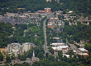
Image of the surrounding Cotswold area
|
|
 |
|
| Country | |
| State | |
| County | Mecklenburg County |
| City | Charlotte |
| Council Districts | 1, 5, 6 |
| Neighborhood Profile Areas | 28, 320, 394 |
| Area | |
| • Total | 850 acre (340 ha) |
| Population
(2015)
|
|
| • Total | 5,199 |
| Time zone | UTC-5 (EST) |
| • Summer (DST) | UTC-4 (EDT) |
| Zip Code |
28211
|
| Area codes | 704, 980 |
| Quality of Life Dashboard | |
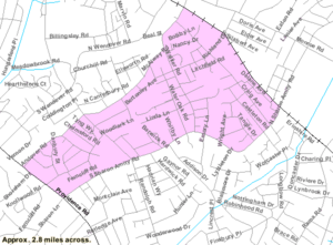
Cotswold is a friendly neighborhood in Charlotte, North Carolina, in the United States. It got its name from a beautiful area in England. Cotswold is famous for its big shopping center, Cotswold Village Shops. This center is located where Randolph and Sharon Amity Roads meet. It was one of the first shopping malls outside the city center.
Today, Cotswold is a popular place to live and shop. It's close to Uptown Charlotte, which is the city's main area. Many older homes from the 1950s and 1960s are being updated.
Cotswold is surrounded by other neighborhoods. These include Randolph Park, Echo Hills, Grier Heights, Myers Park, Oakhurst, Providence Park, Sherwood Forest, and Wendover/Sedgewood.
Contents
Who Lives in Cotswold?
| Historical population | |||
|---|---|---|---|
| Census | Pop. | %± | |
| 2000 | 4,088 | — | |
| 2010 | 4,437 | 8.5% | |
| 2015 (est.) | 5,199 | 17.2% | |
In 2010, about 4,437 people lived in Cotswold. By 2015, the population grew to around 5,199 people. Most residents are White, with a smaller number of Black or African American, Asian, and other races. About 5.7% of the people living here are Hispanic or Latino. The average household income in the area was $51,490.
Getting Around Cotswold
This section explains how people travel in and out of the Cotswold neighborhood.
Buses for Travel
The Charlotte Area Transit System (CATS) has several bus routes that serve Cotswold. These buses help people get to different parts of Charlotte.
- #14 (Providence Road)
- #15 (Randolph Road)
- #29 (UNCC/Southpark)
- #45x (Carmel Road Express)
- #61x (Arboretum Express)
- #62x (Rea Road Express)
Train Lines
A train line from CSX Transportation runs along the eastern edge of Cotswold. This rail line connects Charlotte to other towns like Monroe and Wilmington.
Main Roads
The most important roads in Cotswold are Providence Road, Randolph Road, and Sharon Amity Road. These roads help people drive through and around the neighborhood.
Schools in Cotswold
Students living in Cotswold attend schools that are part of the Charlotte-Mecklenburg Schools system.
Local Schools
Here are some of the schools that serve the Cotswold area:
- Cotswold Elementary
- Eastover Elementary
- Alex Graham Middle School
- Randolph Middle School
- Myers Park High School
Shopping at Cotswold Village Shops
The Cotswold Village Shops is a major shopping center. It is right in the middle of the Cotswold neighborhood.
History of the Shops
The mall first opened in 1963. It was a mix of an indoor mall and an outdoor shopping strip. It was known as Cotswold Mall. Some of the first stores included A&P, the Collins Company, Harris Teeter, Ivey's, and Rose's.
In the early 2000s, the indoor part of the mall was changed. It became an open-air shopping center. Today, Harris Teeter is the only original store that is still open there.
 | Emma Amos |
 | Edward Mitchell Bannister |
 | Larry D. Alexander |
 | Ernie Barnes |

