County of Newcastle, Queensland facts for kids
Quick facts for kids NewcastleQueensland |
|||||||||||||||
|---|---|---|---|---|---|---|---|---|---|---|---|---|---|---|---|

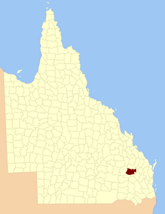
Location within Queensland
|
|||||||||||||||
|
|||||||||||||||
The County of Newcastle is a special kind of area in Queensland, Australia. It's like an old-fashioned way of dividing up land. These divisions are called cadastral divisions. They help people keep track of land for things like property ownership and mapping. Newcastle is located in the Wide Bay–Burnett region of Queensland.
Back on 7 March 1901, the Governor of Queensland made an official announcement. This announcement legally divided Queensland into many counties, including Newcastle. This was done under a law called the Land Act 1897. These counties helped the government manage land across the state.
What are the Borders of Newcastle?
The County of Newcastle has clear borders, almost like invisible fences. These borders help define exactly where the county begins and ends.
- To the east, it shares borders with the counties of Mackenzie and Boondooma.
- To the south, its border follows the Main Dividing Range, which is a big mountain range.
- To the west, the border is marked by the eastern side of the Dawson River's watershed. A watershed is the area of land where all the water drains into a specific river or body of water.
- To the north, the border follows the northern edges of two old land areas called Auburn and Hawkwood Runs. It also follows the Auburn River from where Narayen Creek joins it, all the way down to where the Auburn River meets the Burnett River.
Smaller Areas Inside: Parishes
Just like a big country can be divided into states, counties in Queensland are divided into smaller areas called parishes. These parishes are even smaller sections of land within the county. They help with more detailed land management and mapping. For example, some parishes in Newcastle include Ballymore, Beeron, and Hawkwood. Each parish is part of a larger local government area (LGA), like the Western Downs Region or the North Burnett Region.
 | Leon Lynch |
 | Milton P. Webster |
 | Ferdinand Smith |

