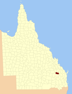
County of Wicklow, Queensland facts for kids
Quick facts for kids WicklowQueensland |
|||||||||||||||
|---|---|---|---|---|---|---|---|---|---|---|---|---|---|---|---|

Location within Queensland
|
|||||||||||||||
|
|||||||||||||||
Wicklow County is a special kind of area in Queensland, Australia. It's like a big land division, used mainly for keeping records of land and property. You can find Wicklow County in the Wide Bay–Burnett region of Queensland.
What is a Cadastral County?
Wicklow County is known as a cadastral division. This means it's a specific area of land created for official purposes. These divisions help the government manage land. They are used for things like property ownership and mapping.
Counties in Queensland are not like the counties you might find in other countries. They don't have their own local governments. Instead, they are just ways to organize land on maps.
How Counties Were Created
The counties in Queensland were officially created a long time ago. On March 7, 1901, the Governor of Queensland made a special announcement. This announcement legally divided Queensland into many counties. This was done under a law called the Land Act 1897.
The law described exactly where each county was located. For Wicklow County, its borders were set by other counties and natural features. For example, it was bordered by Yarrol County to the east. The Dawson River watershed formed part of its western border.
Smaller Areas: Parishes
Just like a state can be divided into counties, counties can be divided into even smaller areas. These smaller areas are called parishes. Wicklow County is made up of several parishes. Each parish has its own name and specific location.
These parishes are also used for land management. They help to pinpoint exact locations within the county. Most of the parishes in Wicklow County are part of the North Burnett Region.
| Parish | Local Government Area | Coordinates |
|---|---|---|
| Auburn | North Burnett | 25°36′S 151°07′E / 25.600°S 151.117°E |
| Boolgal | North Burnett | 25°27′S 150°55′E / 25.450°S 150.917°E |
| Borania | North Burnett | 25°22′S 150°30′E / 25.367°S 150.500°E |
| Cheltenham | North Burnett | 25°34′S 150°49′E / 25.567°S 150.817°E |
| Cloncose | North Burnett | 25°23′S 150°38′E / 25.383°S 150.633°E |
| Dykehead | North Burnett | 25°37′S 151°00′E / 25.617°S 151.000°E |
| Dyngie | North Burnett | 25°28′S 150°31′E / 25.467°S 150.517°E |
| Eidsvold | North Burnett | 25°27′S 151°03′E / 25.450°S 151.050°E |
| Narayen | North Burnett | 25°39′S 150°51′E / 25.650°S 150.850°E |
| Redbank | North Burnett | 25°36′S 150°41′E / 25.600°S 150.683°E |
| Woodbank | North Burnett | 25°35′S 150°30′E / 25.583°S 150.500°E |
| Yerilla | North Burnett | 25°24′S 150°48′E / 25.400°S 150.800°E |
 | Emma Amos |
 | Edward Mitchell Bannister |
 | Larry D. Alexander |
 | Ernie Barnes |

