Covington Township, Michigan facts for kids
Quick facts for kids
Covington Township, Michigan
|
|
|---|---|

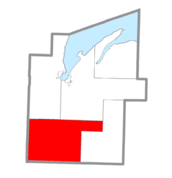
Location within Baraga County (red) and the administered CDP of Covington (pink)
|
|
| Country | |
| State | |
| County | |
| Area | |
| • Total | 196.3 sq mi (508.5 km2) |
| • Land | 192.2 sq mi (497.9 km2) |
| • Water | 4.1 sq mi (10.5 km2) |
| Elevation | 1,627 ft (496 m) |
| Population
(2020)
|
|
| • Total | 375 |
| • Density | 3/sq mi (1.0/km2) |
| Time zone | UTC-5 (Eastern (EST)) |
| • Summer (DST) | UTC-4 (EDT) |
| ZIP code |
49919 (Covington),
49970 (Watton) |
| Area code(s) | 906 |
| FIPS code | 26-18600 |
| GNIS feature ID | 1626139 |
Covington Township is a small area in Baraga County, Michigan. It's a type of local government area called a civil township. In 2020, about 375 people lived here.
Contents
Exploring Covington Township
Covington Township covers a total area of about 508.5 square kilometers (196.3 square miles). Most of this area, about 497.9 square kilometers (192.2 square miles), is land. The rest, about 10.5 square kilometers (4.1 square miles), is water.
You can find two lakes in Covington Township: King Lake and Worm Lake.
Communities in Covington Township
Covington Township has several small communities. These are not official towns but are places where people live.
- Covington is a community located near the crossing of US 141 and M-28 highways. It has its own ZIP code, 49919.
- Leo is another small community within the township.
- Murphy is also an unincorporated community here.
- Perch is a community found in Covington Township.
- Tioga is a place name located between the Tioga River and Pelkie Creek.
- Tunis is a place name found along the Perch River.
- Vermilac is another place name in the township.
- Watton is a community about 4 miles (6.4 km) west of Covington on M-28. It was started in 1903 by August Kotila. Watton has a post office that opened in 1912 and its own ZIP code, 49970.
Weather in Covington Township
Covington Township has a type of weather called a warm-summer humid continental climate. This means it has warm summers and cold, snowy winters.
The hottest temperature ever recorded in Covington was 95°F (35°C) on June 21, 2022. The coldest temperature recorded was -27°F (-33°C) on February 1, 2019.
| Climate data for Covington (Watton), Michigan, 1991–2020 normals, extremes 2000–present | |||||||||||||
|---|---|---|---|---|---|---|---|---|---|---|---|---|---|
| Month | Jan | Feb | Mar | Apr | May | Jun | Jul | Aug | Sep | Oct | Nov | Dec | Year |
| Record high °F (°C) | 50 (10) |
63 (17) |
79 (26) |
84 (29) |
91 (33) |
95 (35) |
93 (34) |
93 (34) |
88 (31) |
84 (29) |
74 (23) |
53 (12) |
95 (35) |
| Mean daily maximum °F (°C) | 21.9 (−5.6) |
25.3 (−3.7) |
36.8 (2.7) |
49.1 (9.5) |
63.7 (17.6) |
72.0 (22.2) |
75.7 (24.3) |
74.4 (23.6) |
66.9 (19.4) |
53.1 (11.7) |
38.4 (3.6) |
27.4 (−2.6) |
50.4 (10.2) |
| Daily mean °F (°C) | 13.9 (−10.1) |
16.1 (−8.8) |
25.4 (−3.7) |
37.9 (3.3) |
51.4 (10.8) |
60.5 (15.8) |
64.4 (18.0) |
63.3 (17.4) |
56.1 (13.4) |
43.7 (6.5) |
31.4 (−0.3) |
20.0 (−6.7) |
40.3 (4.6) |
| Mean daily minimum °F (°C) | 5.9 (−14.5) |
6.8 (−14.0) |
14.1 (−9.9) |
26.6 (−3.0) |
39.2 (4.0) |
49.0 (9.4) |
53.2 (11.8) |
52.1 (11.2) |
45.3 (7.4) |
34.3 (1.3) |
24.3 (−4.3) |
12.6 (−10.8) |
30.3 (−0.9) |
| Record low °F (°C) | −26 (−32) |
−27 (−33) |
−22 (−30) |
−3 (−19) |
19 (−7) |
27 (−3) |
34 (1) |
34 (1) |
26 (−3) |
14 (−10) |
−8 (−22) |
−19 (−28) |
−27 (−33) |
| Average precipitation inches (mm) | 1.72 (44) |
1.41 (36) |
1.53 (39) |
3.20 (81) |
3.02 (77) |
3.42 (87) |
3.60 (91) |
2.98 (76) |
3.53 (90) |
3.36 (85) |
2.45 (62) |
1.72 (44) |
31.94 (812) |
| Average snowfall inches (cm) | 24.8 (63) |
20.9 (53) |
13.6 (35) |
15.6 (40) |
1.0 (2.5) |
0.0 (0.0) |
0.0 (0.0) |
0.0 (0.0) |
0.0 (0.0) |
3.8 (9.7) |
16.9 (43) |
24.7 (63) |
121.3 (309.2) |
| Average extreme snow depth inches (cm) | 18.7 (47) |
23.5 (60) |
23.4 (59) |
12.9 (33) |
1.3 (3.3) |
0.0 (0.0) |
0.0 (0.0) |
0.0 (0.0) |
0.0 (0.0) |
1.4 (3.6) |
7.2 (18) |
11.7 (30) |
23.5 (60) |
| Average precipitation days (≥ 0.01 in) | 19.7 | 15.6 | 11.1 | 13.4 | 13.0 | 11.6 | 11.4 | 10.6 | 13.9 | 15.8 | 16.4 | 19.2 | 171.7 |
| Average snowy days (≥ 0.1 in) | 19.5 | 16.0 | 8.8 | 7.6 | 1.3 | 0.0 | 0.0 | 0.0 | 0.1 | 3.1 | 12.3 | 17.9 | 86.6 |
| Source 1: NOAA | |||||||||||||
| Source 2: National Weather Service (mean maxima/minima, snow depth 2006–2020) | |||||||||||||
Population of Covington Township
The number of people living in Covington Township is quite small. According to the 2020 census, the population was 375 people.
See also
 In Spanish: Municipio de Covington (Míchigan) para niños


