
Crawfish Valley (Bear Creek) facts for kids
Quick facts for kids Crawfish Valley |
|
|---|---|

Crawfish Valley
|
|

Crawfish Valley
Location in Virginia
|
|
| Location | Wythe County, Smyth County Virginia, United States |
| Nearest town | Wytheville, Virginia |
| Area | 18,659 acres (75.51 km2) |
| Administrator | U.S. Forest Service |
Crawfish Valley is a special wild area in the George Washington and Jefferson National Forests in western Virginia. It's so important that the Wilderness Society calls it a "Mountain Treasure." They want to protect it from things like logging and building new roads.
The Forest Service sometimes calls this area "Bear Creek." But the Wilderness Society prefers "Crawfish Valley." This is because the valley is much bigger and acts like a natural divider between Reed Creek and Bear Creek. These are two main streams in the area.
Crawfish Valley is the largest undeveloped area in the Jefferson Forest. It includes part of the famous Appalachian Trail and 24 miles of other trails. This makes it a popular spot for hikers and people who love horseback riding. The area is bordered by Walker Mountain to the north and Brushy and Little Brushy Mountains to the south. Its large size and shape make it perfect for keeping it wild and protected.
This amazing area is also part of the Walker Mountain Cluster.
Contents
Exploring Crawfish Valley: Location & Trails

Crawfish Valley is nestled in the Appalachian Mountains of Southwestern Virginia. You can find it just east of Interstate 81, about 7 miles west of Wytheville, Virginia.
Hiking the Appalachian Trail
A 4.1-mile section of the famous Appalachian Trail (AT) runs through the southern part of Crawfish Valley. If you're hiking south, you'll enter the area at Tilson Gap. You'll leave when you reach the top of Brushy Mountain.
Along the way, the AT crosses the Black Lick-Plaster Bank Turnpike. This old road was once used to transport gypsum (a mineral like plaster) from mines to a shipping point. Gypsum was used as a fertilizer a long time ago.
As you continue south, the AT passes the Crawfish Valley Trail and the Walker Mountain Trail. Then, it reaches Reed Creek in Crawfish Valley. This is a great spot to set up camp! About a mile further, the trail reaches the top of Brushy Mountain. Here, it meets the Crawfish Valley Trail again. This means you can create a fun loop hike by combining parts of the AT with the Crawfish Valley Trail. Remember, the Appalachian Trail here is only for hikers, not horses or bikes. But don't worry, there are other trails nearby for them!
Other Exciting Trails
Crawfish Valley offers many other trails for you to explore:
- Bear Creek Trail (Forest Trail 159): This trail is 3.5 miles long. It's considered easy to moderate and is marked with yellow blazes. You can hike, mountain bike, or ride horses here.
- Crawfish Trail (Forest Trail 6506): This longer trail is 10.0 miles. It's moderate to difficult and marked with orange blazes. It's great for hiking, mountain biking, and horseback riding.
- Walker Mountain Trail (Forest Trail 6501): At 12.3 miles, this trail is moderate and marked with yellow blazes. It's also open for hiking, mountain biking, and horseback riding.
- Ceres Trail (Forest Trail 804.1): This 2.5-mile trail is moderate and has no blazes. You can hike, mountain bike, and ride horses on it.
There's also the Ceres Turnpike (Forest Service Road 804.1). It's a 2.1-mile dirt road that is now closed off, but you can still explore it on foot.

The map next to this text shows the boundaries of Crawfish Valley. You can click the icon in the bottom right corner of the map to make it bigger. For even more details, like topographic maps and aerial views, you can use the coordinates link at the top right of this page.
You can also explore old logging roads in the area. These roads were used a long time ago when trees were harvested. They are becoming overgrown now but can still be walked. Old maps from the United States Geological Survey (USGS) can help you find them. Crawfish Valley is covered by USGS maps called Nebo, Rural Retreat, Big Bend, and Garden Mountain.
Amazing Nature: Plants & Animals
Crawfish Valley is part of a large natural area known as the Central Appalachian Broadleaf Coniferous Forest-Meadow Province. This means you'll find a mix of different trees here.
Forests and Wildlife Openings
In the valleys and along streams, you might see trees like yellow poplar, northern red oak, white oak, and eastern hemlock. On the higher ridges, you'll find chestnut oak, scarlet oak, and yellow pine. There are even a few rare table mountain pine trees. These trees need fire to help their seeds grow, which is why they are not as common anymore.
The area also has about 70 acres of open fields and clearings. These are kept open by controlled burns and mowing. They help create good homes for wildlife. There are also two man-made waterholes for animals to drink from.
Special Animals of Crawfish Valley
.jpg)
Crawfish Valley is home to some very special creatures. The golden-winged warbler is a bird that needs extra protection. It's listed as a "Bird in Jeopardy" by the Department of Interior. The Tennessee dace, a small fish found in Bear Creek and Reed Creek, is also a sensitive species.
There are also potentially over 1200 acres of old-growth forest here. This means there are very old trees that have been growing for a long time without being cut down.
Along Reed Creek, you'll find a mature forest with different types of hardwood trees. There are also meadows and marshy areas. This mix of habitats creates a perfect home for many different birds. You might spot ruffed grouse, wild turkey, and many kinds of warblers. These include the northern parula, blue, black-and-white, and American redstart.
Mountains and Valleys: The Lay of the Land
Crawfish Valley is part of the Ridge-and-Valley Appalachians. This area is known for its long, parallel ridges and valleys. The ridges are made of strong rocks like sandstone, while the valleys are formed from softer rocks like limestone.
The area includes three main mountains: Walker, Brushy, and Little Brushy. It's also where important creeks like Bear Creek, Reed Creek, and Guillion Fork begin. Keep an eye out for Monster Rock. This huge rock sticks out from the top of Walker Mountain on the eastern side of the area.
The lowest point in Crawfish Valley is 2360 feet high in Six Valley. The highest point is 3955 feet, found on the top of Walker Mountain.
How the Forest Service Protects Crawfish Valley
The U.S. Forest Service manages Crawfish Valley. They have different ways of protecting and managing the land.
Bear Creek National Scenic Area
A large part of Crawfish Valley, about 5503 acres in Smyth County, has been named a National Scenic Area. This special designation means that logging and building new roads are not allowed here. However, other activities like mountain biking are still permitted.
Roadless Areas and Conservation
Most of the rest of Crawfish Valley is considered an "inventoried roadless area." This means it's a wild place without roads. A rule called the "Roadless Rule" was put in place to limit road construction in these areas. This rule helps protect the environment and keep these wild places natural. Because most of Crawfish Valley is a roadless area, it's protected from new roads and timber sales.
The Forest Service also uses different classifications to describe how visitors can enjoy the forest. For example, some parts are designated as "Backcountry-Natural Processes." This is the highest level of protection for wild areas. Other parts might be for "Black Bear Habitat" or "Ruffed Grouse Habitat." These designations help guide how the land is used and protected.
A Glimpse into the Past: Cultural History
Crawfish Valley has a rich history. The Mozer Place, an old homesite, is located next to the Crawfish Trail.
In 1998, a survey of about 1085 acres found nine places where ancient people had set up temporary camps. It's also very likely that there are old farmsteads hidden within the area, showing where people lived and worked long ago.
Images for kids
-
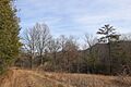
Crawfish Valley
-
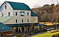
Reed Creek Mill in Wytheville, VA
-
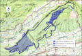
Boundary of the Crawfish Valley wildland as identified by the Wilderness Society
-
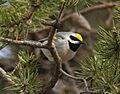
Golden-winged Warbler, Tawas Point State Park, 17 May 2014 (14031168117)
