Croseus Peak facts for kids
Quick facts for kids Croseus Peak |
|
|---|---|
| Highest point | |
| Elevation | 10,388 ft (3,166 m) |
| Geography | |
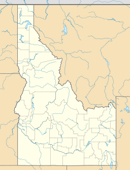
| Location | Custer County, Idaho, U.S. |
| Parent range | White Cloud Mountains |
| Topo map | USGS Horton Peak |
Croseus Peak is a really tall mountain in the White Cloud Mountains of Idaho, USA. It stands at about 10,388 feet (or 3,166 meters) above sea level. Imagine how high that is! This impressive peak is found in a special outdoor area called the Sawtooth National Recreation Area, located in Custer County.
Croseus Peak is interesting because it actually has two main tops, or "summits." One summit is slightly higher than the other, reaching 10,288 feet (3,136 meters). Sometimes, maps even show this second summit as the main one.
Contents
Exploring Croseus Peak's Location
Croseus Peak is a significant part of Idaho's amazing natural landscape. It's nestled within a mountain range and a protected area. Let's learn more about where this peak is found.
Where is Croseus Peak?
Croseus Peak is located in the western part of the United States. Specifically, it's in the state of Idaho. Idaho is known for its beautiful mountains and vast wilderness.
Custer County: Home to Croseus Peak
The peak is in Custer County. This county is in the central part of Idaho. It's a large area with lots of open spaces and natural beauty. Many mountains and forests are found here.
The White Cloud Mountains
Croseus Peak is part of the White Cloud Mountains. This is a mountain range known for its rugged peaks and stunning alpine lakes. The mountains are a popular spot for outdoor adventures.
What Makes the White Cloud Mountains Special?
The White Cloud Mountains are famous for their unique geology. They have many peaks that reach over 10,000 feet high. The scenery here is truly breathtaking, with clear streams and thick forests.
Sawtooth National Recreation Area
Croseus Peak is also inside the Sawtooth National Recreation Area. This is a very important protected area in Idaho. It was created to preserve the natural beauty and wildlife of the region.
Why is the Sawtooth Area Protected?
The Sawtooth National Recreation Area helps keep the land wild and beautiful. It allows people to enjoy nature while protecting it for the future. Activities like hiking, camping, and fishing are popular here.
Understanding Mountain Heights
When we talk about a mountain's height, we often say "above sea level." This helps us compare how tall different mountains are.
What Does "Above Sea Level" Mean?
"Above sea level" means how high a place is compared to the average level of the ocean. The ocean's surface is used as a standard starting point. So, a mountain at 10,000 feet above sea level is 10,000 feet higher than the ocean.
How Are Mountains Measured?
Scientists and mapmakers use special tools to measure mountain heights. Organizations like the USGS create detailed maps. These maps show the exact elevation of peaks like Croseus Peak.
The Role of the USGS
The USGS is a science agency in the U.S. government. They study the Earth's landscape, natural resources, and natural hazards. Their maps, like the Horton Peak map mentioned for Croseus Peak, are very important for understanding our planet.
Croseus Peak's Unique Summits
As mentioned, Croseus Peak has two distinct summits. This is not uncommon for mountains.
Two Tops for One Mountain
Having two summits means the mountain has two high points. For Croseus Peak, one summit is slightly taller than the other. This can sometimes cause confusion on older maps.
Why Do Maps Show Different Summits?
Sometimes, older maps might mark the slightly lower summit as the main one. This could be due to earlier measurements or mapping techniques. Modern mapping is very precise, helping us know the true highest point.


