Cross Lake (Manitoba) facts for kids
Quick facts for kids Cross Lake |
|
|---|---|

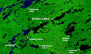
Cross Lake north of Lake Winnipeg
|
|
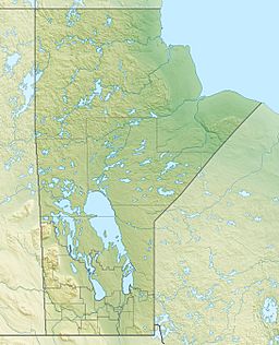
| Location | Manitoba |
| Coordinates | 54°43′N 97°33′W / 54.717°N 97.550°W |
| Primary inflows | Nelson River, Minago River |
| Primary outflows | Nelson River |
| Catchment area | 8,099 km2 (3,127 sq mi) |
| Basin countries | Canada |
| Max. length | 102 km (63 mi) |
| Surface area | 755 km2 (292 sq mi) |
| Average depth | 1.25 m (4 ft 1 in) |
| Max. depth | 12 m (39 ft) |
| Water volume | 0.52 km3 (420,000 acre⋅ft) |
| Residence time | 0.006 years |
| Shore length1 | 1,330 km (830 mi) |
| Surface elevation | 207 m (679 ft) |
| Islands | many islands including Cross Island |
| Settlements | Cross Lake, Cross Lake First Nation |
| 1 Shore length is not a well-defined measure. | |
Cross Lake is a really big lake in Manitoba, Canada. It's located north of Lake Winnipeg and is part of the important Nelson River system. Imagine a long, narrow lake stretching out for about 102 kilometers (63 miles)! That's how long Cross Lake is.
This lake is a key part of the Nelson River's journey. The Nelson River flows into Cross Lake from the west. It also leaves the lake, continuing its path north towards Sipiwesk Lake. Another river, the Minago River, also flows into Cross Lake from the west.
Contents
Managing the Lake's Water
The water level in Cross Lake is carefully controlled. This is done by a company called Manitoba Hydro. They manage the water at the Jenpeg Generating Station. This station is located at the southern end of the lake. It helps to make sure the water levels are right for both the environment and for generating electricity.
How Water Flows In and Out
The Nelson River has two main channels that bring water into Cross Lake. The western channel enters the lake near the Jenpeg Dam. The eastern channel flows in closer to the communities of Cross Lake and Cross Lake First Nation. After passing through Cross Lake, the Nelson River continues its journey north.
Exploring Old Travel Routes
Long ago, people used to travel across Manitoba using lakes and rivers. They would also use "portages." A portage is a path where people carry their canoes and goods over land between two waterways.
Connecting to Other Waterways
From a place called Moon Lake, which is where the Minago River starts, there was a portage. This path led to South Moose Lake and then to the Saskatchewan River. This shows how interconnected the waterways were for travel.
On the southeast side of Cross Lake, there was another important route. Travelers would go through the Walker River, Walker Lake, and Kapaspwaypanik Lake. From there, the Kapaspwaypanik Portage connected them to the Carrot River and Oxford Lake. Oxford Lake is part of the Hayes River system, which was also a major travel route. These routes were vital for trade and movement for Indigenous peoples and early explorers.
 | Kyle Baker |
 | Joseph Yoakum |
 | Laura Wheeler Waring |
 | Henry Ossawa Tanner |


