Hayes River facts for kids
Quick facts for kids Hayes River |
|
|---|---|

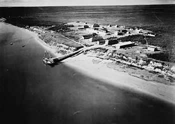
York Factory on the Hayes River, circa 1925
|
|
|
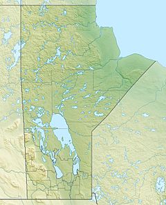
Location of the mouth of the Hayes River in Manitoba.
|
|
| Country | Canada |
| Province | Manitoba |
| Region | Northern Region |
| Physical characteristics | |
| Main source | Molson Lake 221 m (725 ft) 54°18′55″N 96°41′31″W / 54.31528°N 96.69194°W |
| River mouth | Hudson Bay 0 m (0 ft) 57°03′27″N 92°10′45″W / 57.05750°N 92.17917°W |
| Length | 483 km (300 mi) |
| Basin features | |
| River system | Hudson Bay drainage basin |
| Basin size | 108,000 km2 (42,000 sq mi) |
| Tributaries |
|
The Hayes River is a river in Northern Manitoba, Canada. It flows from Molson Lake to Hudson Bay at York Factory. This river was very important in Canada's early history. Today, it is a Canadian Heritage River. It is also the longest naturally flowing river in Manitoba.
Contents
River Journey: From Lake to Bay
The Hayes River starts at Molson Lake, which is about 221 m (725 ft) above sea level. This lake is about 90 km (56 mi) northeast of Lake Winnipeg. A small stream called Paimusk Creek flows into Molson Lake. This stream starts very close to the Nelson River.
Connecting Rivers and Portages
After leaving Molson Lake, the Hayes River flows north and northeast. It reaches Robinson Lake about 16 km (9.9 mi) away. Before Robinson Lake, another interesting river joins it: the Echimamish River. This river connects directly to the Nelson River. Long ago, explorers and traders called "voyageurs" used the Echimamish River. It helped them travel from York Factory on Hudson Bay, up the Hayes River, and then across to the Nelson River. From there, they could go downstream to Norway House, which is at the north end of Lake Winnipeg.
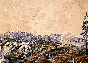
Northeast of Robinson Lake, you'll find Robinson Falls. There's also a long path called the Robinson portage, which is about a mile long. This was the longest portage between Hudson Bay and Edmonton. A "portage" is a place where people had to carry their canoes and goods over land to get around rapids or waterfalls.
Waterfalls and Lakes
The Hayes River also cuts through Logan Lake. It passes a settlement called Wetikoweskwattam and then flows into Opiminegoka Lake. Here, it takes in the Lawford River. The river then goes through Windy Lake and over Wipanipanis Falls. Finally, it reaches Oxford Lake, about 80 km (50 mi) northeast of its source.
The river flows out of Oxford Lake at a place called Oxford House. It then goes southeast over Trout Falls to Knee Lake. After Knee Lake, the Hayes River flows over many rapids and through several channels. It then widens into Swampy Lake.
The Dramstone and Rapids
At the east end of Swampy Lake, about 200 km (120 mi) from Molson Lake, is a special spot called the Dramstone. This was a place where travelers heading west would take a drink to celebrate leaving the hardest part of the river behind them. In one 80 km (50 mi) section, the Hayes River drops a lot in height.
From Swampy Lake, the river continues through many rapids. It passes Brassy Hill, which rises 140 m (460 ft) above the river. The High Hill River joins the Hayes from the right. The Hayes River then flows northeast through a small canyon for about 100 km (62 mi). Along this stretch, it goes over Whitemud Falls and Berwick Falls. The Fox River, a major tributary, joins the Hayes at this point.
Reaching Hudson Bay
The Hayes River keeps flowing northeast. It takes in another major river, the Gods River. Finally, it reaches its mouth at Hudson Bay. This is right next to the mouth of the larger Nelson River. About 200 km (120 mi) upriver from York Factory was Rock Depot. Here, large York boats had to be swapped for smaller canoes. It was a long journey with 30 portages from Rock Depot to Norway House.
In the past, different parts of the Hayes River had different names. Some of these names included Steel River, Hill River, and Trout River.
River Features and Size
The Hayes River has many interesting features. These include whitewater rapids, large lakes, beautiful waterfalls, and deep valleys. Near Hudson Bay, it has tidal flats where the river meets the ocean.
The river is 483 km (300 mi) long. On average, it carries about 590 m3/s (21,000 cu ft/s) of water. The area of land that drains into the Hayes River, called its drainage basin, covers 108,000 km2 (42,000 sq mi).
History of the Hayes River
Long before Europeans arrived, First Nations people used the Hayes River. They left ancient campsites and pictographs along its banks. The river flows through the traditional lands of four First Nations: Norway House Cree Nation, Bunibonibee Cree Nation, Shamattawa First Nation, and York Factory Cree Nation. Even today, the river is important for their traditional hunting and fishing.
European Arrival and Fur Trade
After Europeans came to North America, the Hayes River became a key route for developing Canada. In 1684, French explorer Pierre Radisson named the river after Sir James Hayes. James Hayes was a founding member of the Hudson's Bay Company (HBC) and secretary to Prince Rupert.
The HBC built York Factory at the mouth of the Hayes River in 1684. This became the main headquarters for the HBC in North America until 1957. From 1670 to 1870, the Hayes River was the main travel route. Explorers, fur traders, and European settlers used it to go between York Factory and Norway House in the middle of the continent.
To get to the Hayes from Norway House, travelers would go a short distance down the Nelson River. Then, they would turn onto the Echimamish River. This river is a "bifurcation river," meaning it connects two different river systems: the Hayes River and the Nelson River. This route became the last part of the York Factory Express. This was a famous route that connected the HBC's western headquarters at Fort Vancouver to York Factory.
Nature and Wildlife
The Hayes River flows through some of Manitoba's most natural and untouched areas. It is home to many amazing animals. You might see polar bears, wolverines, woodland caribou, and ivory gulls. The river itself has fish like sturgeon and brook trout. Near the bay, you might even spot beluga whales. Other birds like bald eagles and large animals like moose also live here.
As you travel along the river, the landscape changes. In the south, you'll see thick spruce forests. Further north, the trees become smaller, like black spruce and tamarack. There are also many wet, marshy areas called bogs.
The Hayes River was named a Canadian Heritage River on June 11, 2006. This means it's recognized for its natural beauty and historical importance. There is a stone marker at the meeting point of the God's and Hayes rivers. It remembers a young canoe guide who passed away there.
Recreation and Economy
Today, the Hayes River remains untouched. There are no dams or big developments along its course. Because it's the longest naturally flowing river in Manitoba, it's a popular place for canoe trips.
The river offers many ways for visitors and local people to enjoy nature and learn about history. You can go canoeing, boating, hunting, or fishing. It's also a great place to learn about Canada’s fur trade history.
Main Tributaries
- Fox River (joins from the left)
- Gods River (joins from the right)
- Knee Lake (a large lake the river flows through)
- Oxford Lake (another large lake the river flows through)
- Lawford River (joins from the left)
See also
 In Spanish: Río Hayes para niños
 | Madam C. J. Walker |
 | Janet Emerson Bashen |
 | Annie Turnbo Malone |
 | Maggie L. Walker |


