Croswell, Michigan facts for kids
Quick facts for kids
Croswell, Michigan
|
|
|---|---|

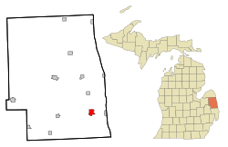
Location of Croswell, Michigan
|
|
| Country | United States |
| State | Michigan |
| County | Sanilac |
| Area | |
| • Total | 2.42 sq mi (6.27 km2) |
| • Land | 2.30 sq mi (5.97 km2) |
| • Water | 0.12 sq mi (0.30 km2) |
| Elevation | 732 ft (223 m) |
| Population
(2020)
|
|
| • Total | 2,322 |
| • Density | 1,007.81/sq mi (389.10/km2) |
| Time zone | UTC-5 (Eastern (EST)) |
| • Summer (DST) | UTC-4 (EDT) |
| ZIP code |
48422
|
| Area code(s) | 810 |
| FIPS code | 26-18920 |
| GNIS feature ID | 0624126 |
Croswell is a city in Sanilac County in the U.S. state of Michigan. It is located in the eastern part of the state. In 2020, about 2,322 people lived there.
Contents
History of Croswell
The area where Croswell is now was first settled in 1845. It was originally known as Black River. Later, it was called Davisville. This name honored the town's first postmaster. In 1877, the town was renamed Croswell. This new name was chosen to honor Governor Charles Croswell. Croswell officially became a city in 1881.
Geography of Croswell
Croswell is part of a region in Michigan called "the Thumb." This name comes from its shape on a map. The city covers about 2.41 square miles (6.24 square kilometers). Most of this area is land. A small part is water. Croswell is also considered part of the "Blue Water Area." This is a smaller region within the Thumb.
Population and People
| Historical population | |||
|---|---|---|---|
| Census | Pop. | %± | |
| 1880 | 447 | — | |
| 1890 | 504 | 12.8% | |
| 1900 | 606 | 20.2% | |
| 1910 | 1,380 | 127.7% | |
| 1920 | 1,678 | 21.6% | |
| 1930 | 1,470 | −12.4% | |
| 1940 | 1,381 | −6.1% | |
| 1950 | 1,775 | 28.5% | |
| 1960 | 1,817 | 2.4% | |
| 1970 | 1,954 | 7.5% | |
| 1980 | 2,073 | 6.1% | |
| 1990 | 2,174 | 4.9% | |
| 2000 | 2,467 | 13.5% | |
| 2010 | 2,447 | −0.8% | |
| 2020 | 2,322 | −5.1% | |
| U.S. Decennial Census | |||
How Many People Live Here?
According to the 2010 census, 2,447 people lived in Croswell. There were 971 households and 649 families. The city had about 1,068 people per square mile.
Many homes had children under 18 living there. About 45.8% of households were married couples. The average household had 2.51 people. The average family had 3.00 people.
The average age of people in Croswell was 38.8 years. About 26.8% of residents were under 18. About 14.2% were 65 years or older.
Local Industries
The areas around Croswell are mostly used for farming. Farmers grow many different crops here. These include corn, wheat, oats, and soybeans. They also grow sugar beets, peas, and alfalfa (hay).
Famous Landmarks
One of Croswell's most famous spots is the "Be Good to Your Mother-In-Law" footbridge. This bridge crosses the Black River. It is a suspension bridge made of cables and wood planks. Locals often call it the "Swinging Bridge." An annual festival is even held there.
Croswell also has a unique traffic light. It is one of the last fixed 4-way traffic signals in Michigan. You can find it at the corner of Howard Street and Sanborn Avenue.
Fun Events
Croswell hosts one of Michigan's oldest fairs. The Croswell Agricultural Society Fair started in 1884. It takes place every summer. You can find it at the Croswell Fairgrounds. These are located at Harrington and Croswell Roads.
Getting Around
Arnold Field is a small airport near Croswell. It is used by the public. The airport is about 2 miles (3.2 kilometers) northeast of the city center.
See also
 In Spanish: Croswell (Míchigan) para niños
 | Sharif Bey |
 | Hale Woodruff |
 | Richmond Barthé |
 | Purvis Young |

