Curiñanco facts for kids
Quick facts for kids
Curiñanco
|
|
|---|---|
|
village
|
|

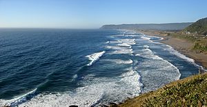
Curiñanco’s beach during the summer, viewed from its southern access. The promontory that can be seen in the background is part of the Punta Curiñanco Protected Coastal Area.
|
|
| Region | Los Ríos |
| Province | Valdivia |
| Municipalidad | Valdivia |
| Comuna | Valdivia |
| Government | |
| • Type | Municipalidad |
| Population
(2002 census [1])
|
|
| • Total | 274 |
| Time zone | UTC−04:00 (Chilean Standard) |
| • Summer (DST) | UTC−03:00 (Chilean Daylight) |
| Area code(s) | Country + town = 56 + 43 |
Curiñanco is a small village located on the coast in the Los Ríos Region of Chile. It is part of the Valdivia area, which is like a local district. The village sits between the mouths of two rivers, the Valdivia River and the Lingue River.
In 2002, Curiñanco had a population of 274 people. You can reach the village by road from the south, starting from the town of Niebla. There's also another road from the southeast, which begins in Torobayo and goes past Punucapa on its way to the coast. The name Curiñanco comes from a respected local leader named Curiñancu, who was the father of the famous Mapuche leader Lautaro.
Sports in Curiñanco
The village has its own amateur football (soccer) team called the Curiñanco Sports Club. This club was started a long time ago, on December 8, 1918. The team plays in the Niebla Sports League, competing against other local teams from nearby areas.
Community Life
Curiñanco is home to an important group of people called the Kiñe Wen Indigenous Community of Curiñanco. This community helps keep their traditions and culture alive in the village.
See also
 In Spanish: Curiñanco para niños

