Cyr Plantation, Maine facts for kids
Quick facts for kids
Cyr Plantation, Maine
Plantation Cyr
|
|
|---|---|
|
Plantation
|
|

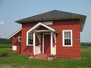
The Governor Brann School, one the plantation's former rural schoolhouses
|
|

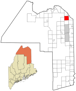
Location of Cyr Plantation, Maine
|
|
| Country | United States |
| State | Maine |
| County | Aroostook |
| Organized | 1870 |
| Area | |
| • Total | 38.3 sq mi (99.3 km2) |
| • Land | 38.3 sq mi (99.3 km2) |
| • Water | 0 sq mi (0 km2) |
| Population
(2020)
|
|
| • Total | 78 |
| • Density | 2.037/sq mi (0.785/km2) |
| Time zone | UTC-5 (Eastern (EST)) |
| • Summer (DST) | UTC-4 (EDT) |
| Zip code |
04785
|
| Area code(s) | 207 |
| FIPS code | 23-15990 |
| GNIS feature ID | 0582430 |
Cyr Plantation (in French: Plantation Cyr) is a small community in Aroostook County, Maine, United States. A "plantation" in Maine is a type of small town or settlement. In 2020, about 78 people lived there.
History of Cyr Plantation
People first started settling in the area now known as Cyr Plantation in the mid-1800s. Back then, it was called Township Letter L. A road was built around that time, connecting the Aroostook River to Grand Falls in New Brunswick, Canada. Today, this road goes between Caribou, Maine, and Hamlin, Maine.
Many early settlers received land grants near this road and Hammond Brook. They used the land for farming. The community officially became Cyr Plantation on March 12, 1870. It was named after the many Cyr families living in the area. This included Andre Cyr and his father Christopher, who were among the first Cyrs to settle there.
Where is Cyr Plantation?
Cyr Plantation is located in Aroostook County, Maine. The United States Census Bureau says the plantation covers a total area of 99.3 square kilometers (about 38.3 square miles). All of this area is land, meaning there are no large lakes or rivers within its borders.
People of Cyr Plantation
The number of people living in Cyr Plantation has changed over the years. Here's a look at the population from 1870 to 2020:
| Historical population | |||
|---|---|---|---|
| Census | Pop. | %± | |
| 1870 | 376 | — | |
| 1880 | 558 | 48.4% | |
| 1890 | 429 | −23.1% | |
| 1900 | 502 | 17.0% | |
| 1910 | 531 | 5.8% | |
| 1920 | 479 | −9.8% | |
| 1930 | 521 | 8.8% | |
| 1940 | 433 | −16.9% | |
| 1950 | 256 | −40.9% | |
| 1960 | 233 | −9.0% | |
| 1970 | 155 | −33.5% | |
| 1980 | 147 | −5.2% | |
| 1990 | 142 | −3.4% | |
| 2000 | 117 | −17.6% | |
| 2010 | 103 | −12.0% | |
| 2020 | 78 | −24.3% | |
| U.S. Decennial Census | |||
In 2000, there were 117 people living in 42 homes. Most of these homes (33) were families. The population density was about 3 people per square mile.
Many people in Cyr Plantation speak French. In 2000, about 58% of people spoke French at home, while about 42% spoke English.
| Languages (2000) | Percent |
|---|---|
| Spoke French at home | 58.33% |
| Spoke English at home | 41.67% |
The average age of people in Cyr Plantation in 2000 was 40 years old. About 30% of the population was under 18 years old.
See also
 In Spanish: Cyr Plantation para niños
 | Charles R. Drew |
 | Benjamin Banneker |
 | Jane C. Wright |
 | Roger Arliner Young |

