
Cómpeta facts for kids
Quick facts for kids
Cómpeta
|
||
|---|---|---|

View of Cómpeta
|
||
|
||

Cómpeta
Location in Spain
|
||
| Country | ||
| Autonomous community | ||
| Province | Málaga Province | |
| Comarca | Axarquía-Costa del Sol | |
| Area | ||
| • Total | 54.7 km2 (21.1 sq mi) | |
| Elevation | 636 m (2,087 ft) | |
| Population
(2018)
|
||
| • Total | 3,745 | |
| • Density | 68.46/km2 (177.32/sq mi) | |
| Time zone | UTC+1 (CET) | |
| • Summer (DST) | UTC+2 (CEST) | |
| Postal code |
29754
|
|
| Area code(s) | (+34) 952 | |
| Website | http://www.competa.es/ | |

Cómpeta is a charming town and municipality located in southern Spain. It's part of the Axarquía region in the Málaga Province, which is in the Andalusia area. This lovely town is about 18 kilometers (11 miles) from the sunny Costa del Sol coast. It's also about 52 kilometers (32 miles) from Málaga, the capital city of the province.
Cómpeta sits high up at 638 meters (2,093 feet) above sea level. It's nestled in the foothills of La Maroma, which is the tallest peak in the Sierra de Tejeda mountains. The town's population of around 4,000 people lives on the southern slopes of the Sierra de Almijara. People from Cómpeta are called competeños. Many people from other European countries, like the United Kingdom, Germany, Denmark, The Netherlands, and Norway, also live here.
The town's special protector is San Sebastian. Every year, during the last weekend of July, Cómpeta celebrates a big party or fiesta to honor him. Another important festival is the 'Noche del Vino' (Night of the Wine), held every year on August 15th (Assumption Day). This festival is so popular that it's officially recognized as a special tourist event in Andalusia! Getting to Cómpeta is easy; it's about an hour's drive from Málaga Airport, first along the coast and then up a well-kept mountain road.
Contents
Exploring Cómpeta's Surroundings
Mountains and Nature
Cómpeta is located just southwest of the beautiful Sierras of Tejeda, Almijara and Alhama Natural Park. This park is a huge protected area, covering about 20,543 hectares (over 50,000 acres). It's home to many different plants and animals. The park includes parts of several towns, including Cómpeta.
The highest mountain you can see from Cómpeta is La Maroma, which stands at 2,065 meters (6,775 feet) tall. The area around the town is very hilly, especially towards the northwest, near the Granada Province. Other important mountains nearby include Cerro Lucero (1,779 m), Cisne (1,600 m), and Verde (1,554 m). There's also a cool spot called Tajo de las Grajas, which is a 200-meter-long (656 feet) cliff.
-
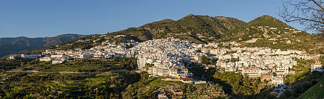
A wide view of Cómpeta at sunset.

Local Areas
Cómpeta has a small neighborhood in the mountains called El Acebuchal. It's a quiet place with a few houses spread out on a hillside. The people living there recently built a small chapel for their community. This area stretches for several kilometers towards another town called Frigiliana.
A Glimpse into History
Cómpeta has a long history that goes all the way back to Roman times! Its name, Cómpeta, comes from the Latin words Compita-Orum. This means "crossing of roads." It's believed that in Roman times, this spot was a busy meeting place. People would gather here for celebrations and to buy and sell goods. While there aren't many old written records to prove this, it's thought to be how the town first started.
See also
 In Spanish: Cómpeta para niños
