Dalton, Nebraska facts for kids
Quick facts for kids
Dalton, Nebraska
|
|
|---|---|
|
Village
|
|

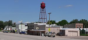
Dalton, looking northeast across U.S. Route 385
|
|

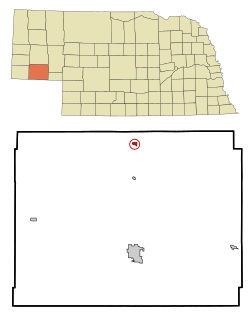
Location of Dalton, Nebraska
|
|
| Country | United States |
| State | Nebraska |
| County | Cheyenne |
| Area | |
| • Total | 0.34 sq mi (0.89 km2) |
| • Land | 0.34 sq mi (0.89 km2) |
| • Water | 0.00 sq mi (0.00 km2) |
| Elevation | 4,259 ft (1,298 m) |
| Population
(2020)
|
|
| • Total | 284 |
| • Density | 825.58/sq mi (318.80/km2) |
| Time zone | UTC-7 (Mountain (MST)) |
| • Summer (DST) | UTC-6 (MDT) |
| ZIP code |
69131
|
| Area code(s) | 308 |
| FIPS code | 31-12070 |
| GNIS feature ID | 2398672 |
Dalton is a small village located in Cheyenne County, Nebraska, in the United States. In 2020, about 284 people lived there. It's a quiet place with a rich history connected to railroads.
Contents
History of Dalton
How Dalton Started
Dalton began around the year 1900. This happened when the Nebraska, Wyoming and Western Railroad decided to extend its tracks to this spot. The railroad company bought land in 1900. This land became an important stop for trains carrying goods and people. Dalton quickly grew into a small town because of the railroad. By September 1900, trains were running daily from Dalton. They went north to Deadwood, South Dakota and south to Denver, Colorado.
Dalton's Post Office
The first post office in Dalton opened on June 7, 1902. Warren Woolsey was the very first postmaster. He was in charge of all the mail for the town.
Newspapers in Dalton
The first newspaper in Dalton was called the Dalton Herald. It started in 1909. We don't know exactly when it stopped being published, but it wasn't around for very long. Later, in 1914, a new newspaper called the Dalton Delegate took its place. This paper was published every Friday. It continued to share local news until September 1951.
Where Did the Name Dalton Come From?
The exact reason why Dalton was named Dalton is a bit of a mystery! Some people think it might have been named after a town called Dalton, Massachusetts. Others believe it was named after an early settler named Patrick Dalton. Another idea is that it was named after Patrick J. Dalton. He was an important person at the Burlington Railroad.
Geography of Dalton
Dalton is a small village, covering about 0.34 square miles (0.89 square kilometers). All of this area is land.
Dalton's Climate
Dalton experiences a climate with warm summers and cold winters. Here's a look at the typical weather:
| Climate data for Dalton, Nebraska (1991–2020 normals, extremes 1961–2018) | |||||||||||||
|---|---|---|---|---|---|---|---|---|---|---|---|---|---|
| Month | Jan | Feb | Mar | Apr | May | Jun | Jul | Aug | Sep | Oct | Nov | Dec | Year |
| Record high °F (°C) | 73 (23) |
78 (26) |
82 (28) |
89 (32) |
96 (36) |
102 (39) |
104 (40) |
102 (39) |
98 (37) |
91 (33) |
78 (26) |
78 (26) |
104 (40) |
| Mean maximum °F (°C) | 60.7 (15.9) |
63.1 (17.3) |
73.9 (23.3) |
81.3 (27.4) |
87.8 (31.0) |
93.6 (34.2) |
98.0 (36.7) |
95.4 (35.2) |
91.2 (32.9) |
81.0 (27.2) |
71.4 (21.9) |
61.1 (16.2) |
98.4 (36.9) |
| Mean daily maximum °F (°C) | 39.4 (4.1) |
41.3 (5.2) |
51.3 (10.7) |
59.3 (15.2) |
68.6 (20.3) |
80.5 (26.9) |
87.0 (30.6) |
84.9 (29.4) |
75.8 (24.3) |
61.3 (16.3) |
48.9 (9.4) |
39.6 (4.2) |
61.5 (16.4) |
| Daily mean °F (°C) | 29.5 (−1.4) |
30.7 (−0.7) |
39.9 (4.4) |
47.5 (8.6) |
57.3 (14.1) |
67.9 (19.9) |
74.3 (23.5) |
72.3 (22.4) |
63.1 (17.3) |
49.6 (9.8) |
38.2 (3.4) |
30.0 (−1.1) |
50.0 (10.0) |
| Mean daily minimum °F (°C) | 19.6 (−6.9) |
20.1 (−6.6) |
28.5 (−1.9) |
35.6 (2.0) |
46.1 (7.8) |
55.4 (13.0) |
61.6 (16.4) |
59.6 (15.3) |
50.5 (10.3) |
37.9 (3.3) |
27.5 (−2.5) |
20.4 (−6.4) |
38.6 (3.7) |
| Mean minimum °F (°C) | −2.9 (−19.4) |
−3.6 (−19.8) |
6.1 (−14.4) |
17.7 (−7.9) |
29.2 (−1.6) |
40.5 (4.7) |
49.4 (9.7) |
46.9 (8.3) |
32.3 (0.2) |
18.4 (−7.6) |
6.3 (−14.3) |
−4.3 (−20.2) |
−13.5 (−25.3) |
| Record low °F (°C) | −31 (−35) |
−26 (−32) |
−16 (−27) |
−7 (−22) |
18 (−8) |
30 (−1) |
41 (5) |
35 (2) |
15 (−9) |
−2 (−19) |
−8 (−22) |
−32 (−36) |
−32 (−36) |
| Average precipitation inches (mm) | 0.46 (12) |
0.64 (16) |
1.14 (29) |
2.27 (58) |
3.47 (88) |
2.97 (75) |
2.91 (74) |
1.97 (50) |
1.85 (47) |
1.59 (40) |
0.69 (18) |
0.57 (14) |
20.53 (521) |
| Average snowfall inches (cm) | 7.3 (19) |
8.8 (22) |
6.1 (15) |
6.4 (16) |
1.6 (4.1) |
0.0 (0.0) |
0.0 (0.0) |
0.0 (0.0) |
0.2 (0.51) |
3.1 (7.9) |
5.6 (14) |
9.0 (23) |
48.1 (122) |
| Average precipitation days (≥ 0.01 in) | 3.8 | 4.9 | 5.6 | 8.0 | 9.7 | 9.9 | 7.9 | 7.5 | 6.0 | 5.9 | 3.5 | 3.6 | 76.3 |
| Average snowy days (≥ 0.1 in) | 2.3 | 3.1 | 2.3 | 1.3 | 0.4 | 0.0 | 0.0 | 0.0 | 0.1 | 0.9 | 1.9 | 2.4 | 14.7 |
| Source: NOAA (mean maxima/minima 1981–2010) | |||||||||||||
People of Dalton
Dalton's population has changed over the years. Here's how many people have lived there during different census counts:
| Historical population | |||
|---|---|---|---|
| Census | Pop. | %± | |
| 1910 | 207 | — | |
| 1920 | 295 | 42.5% | |
| 1930 | 453 | 53.6% | |
| 1940 | 358 | −21.0% | |
| 1950 | 417 | 16.5% | |
| 1960 | 503 | 20.6% | |
| 1970 | 354 | −29.6% | |
| 1980 | 345 | −2.5% | |
| 1990 | 282 | −18.3% | |
| 2000 | 332 | 17.7% | |
| 2010 | 315 | −5.1% | |
| 2020 | 284 | −9.8% | |
| U.S. Decennial Census | |||
Dalton in 2010
In 2010, there were 315 people living in Dalton. These people lived in 142 different homes. About 81 of these homes were families. The village had about 926 people per square mile.
- Homes and Families:
- 26.8% of homes had children under 18.
- 45.8% were married couples living together.
- 9.2% had a female head of household with no husband.
- 2.1% had a male head of household with no wife.
- 43.0% were not families (like single people living alone).
- People Living Alone: 38.0% of all homes had only one person living there. About 17.7% of these single people were 65 years old or older.
- Average Household Size: On average, there were 2.22 people in each home. For families, the average was 2.93 people.
- Age Groups: The average age in Dalton was 41.1 years.
- 24.8% of residents were under 18.
- 6% were between 18 and 24.
- 22.5% were between 25 and 44.
- 27.6% were between 45 and 64.
- 19% were 65 years old or older.
- Gender: The population was almost evenly split between males and females. 50.2% were male and 49.8% were female.
Schools in Dalton
Dalton is home to Leyton Public High School. The school district is called Leyton Public Schools. The communities of Dalton and Gurley joined their school districts in 1978 to create Leyton Public Schools. You can find more information at Leyton Public Schools.
See also
 In Spanish: Dalton (Nebraska) para niños
 | Kyle Baker |
 | Joseph Yoakum |
 | Laura Wheeler Waring |
 | Henry Ossawa Tanner |

