
Dandenong Creek facts for kids
Quick facts for kids Dandenong |
|
|---|---|

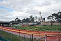
Dandenong Creek channeled as an urban stream in Dandenong
|
|

|
|
| Native name | Narra Narrawong, Dandinnong |
| Other name(s) | Dand-y-non, Tanjenong |
| Country | Australia |
| State | Victoria |
| Region | South East Coastal Plain (IBRA), Greater Melbourne |
| Local government area | City of Monash |
| Physical characteristics | |
| Main source | Dandenong Ranges |
| 2nd source | Bungalook Creek near Heathmont 556 m (1,824 ft) 37°50′8″S 145°15′25″E / 37.83556°S 145.25694°E |
| River mouth | confluence with the Eumemmerring Creek to form the Patterson River southwest of Bangholme 6 m (20 ft) 38°2′37″S 145°10′29″E / 38.04361°S 145.17472°E |
| Length | 53 km (33 mi) |
| Basin features | |
| River system | Port Phillip catchment |
| Tributaries |
|
The Dandenong Creek is a waterway in eastern and south-eastern Greater Melbourne, Victoria, Australia. It's known as an "urban creek" because it flows through cities and towns. It's part of the Port Phillip catchment area, meaning its waters eventually flow into Port Phillip Bay.
Contents
Where is Dandenong Creek?
Dandenong Creek starts high up in the Dandenong Ranges near a place called Olinda. It gets its water from smaller streams, including Bungalook Creek. The creek flows mostly south and southwest. Along its journey, other smaller creeks, like Corhanwarrabul Creek, join it.
Eventually, Dandenong Creek meets Eumemmerring Creek. Together, they form a human-made river called the Patterson River, southwest of Bangholme. From its start to where it joins the Patterson River, the creek drops about 550 meters (1,800 feet) in height over its 53-kilometer (33-mile) path.
Creek Health and Wildlife
Because Dandenong Creek flows through many urban areas, its health can vary. Some parts are quite healthy, while others are not as good. People have been working hard on clean-up projects to make the creek healthier.
The creek is also home to a special type of tree called the Yarra gum. This is one of the largest groups of these trees still left.
Sometimes, an industrial wastewater stream called Old Joes Creek flows into Dandenong Creek. This stream can carry pollution, like heavy metals, from nearby industrial areas. Authorities are working to stop this pollution from spreading further down the creek.
Fun Along the Creek
A popular bike path, called the Dandenong Creek Trail, runs alongside the creek for a long distance. It's a great place for cycling, walking, and enjoying nature.
What Does the Name Dandenong Mean?
The original owners of the land around Dandenong Creek were the Indigenous Bunurong people. They called the creek Narra Narrawong. The name "Dandenong" was also used by early European settlers, sometimes spelled Dand-y-non or Tanjenong. It's thought to mean "high" or "lofty" in the Aboriginal Bunwurrung language.
A Glimpse into History
The first European person believed to have seen the creek near its source was a botanist named Daniel Bunce. This happened way back in 1839.
Crossing the Creek
Many bridges cross Dandenong Creek. These include roads for cars, railway lines for trains, and paths for people walking or riding horses. Some of the major crossings include:
- Roads like Perry Road, Greens Road, and Wellington Road.
- Major highways such as the EastLink and Monash Freeway.
- Bridges for the Dandenong Creek Trail and other walking paths.
- The Gippsland Railway bridge, which carries trains over the creek.

Images for kids
-

Dandenong Creek and a pedestrian bridge in Dandenong Park.
-
The EastLink bridge crossing Dandenong Creek.
