Dasher, Georgia facts for kids
Quick facts for kids
Dasher, Georgia
|
|
|---|---|

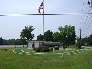
Dasher City Hall and Fire Department
|
|

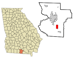
Location in Lowndes County and the state of Georgia
|
|
| Country | United States |
| State | Georgia |
| County | Lowndes |
| Settled | 1889 |
| Incorporated | 1968 |
| Area | |
| • Total | 4.96 sq mi (12.85 km2) |
| • Land | 4.60 sq mi (11.91 km2) |
| • Water | 0.37 sq mi (0.95 km2) |
| Elevation | 180 ft (55 m) |
| Population
(2020)
|
|
| • Total | 890 |
| • Density | 193.60/sq mi (74.75/km2) |
| Time zone | UTC-5 (Eastern (EST)) |
| • Summer (DST) | UTC-4 (EDT) |
| ZIP code |
31601
|
| Area code(s) | 229 |
| FIPS code | 13-21744 |
| GNIS feature ID | 0313320 |
Dasher is a small town located in Lowndes County, Georgia, in the United States. In 2020, about 890 people lived there. It's a quiet place with a rich history.
Contents
History of Dasher
Dasher started as a train station in 1889. It was built along the new Georgia Southern and Florida Railway line. The station was named after V. F. Dasher, who lived nearby. Many years later, in 1968, the state government of Georgia officially recognized Dasher as a town. This process is called "incorporation."
Geography of Dasher
Dasher is in the southeastern part of Lowndes County. You can find it at these coordinates: 30°44′43″N 83°13′23″W / 30.74528°N 83.22306°W. U.S. Route 41 is a main road that goes right through the town. If you travel northwest on this road, you'll reach Valdosta, which is the main city of the county, about 7 miles away. Going southeast for about 6 miles will take you to Lake Park.
The United States Census Bureau measures land and water areas. They say Dasher covers a total area of about 12.9 square kilometers (or 4.96 square miles). Most of this area, about 11.8 square kilometers (4.60 square miles), is land. The rest, about 1.1 square kilometers (0.37 square miles), is water.
People of Dasher (Demographics)
| Historical population | |||
|---|---|---|---|
| Census | Pop. | %± | |
| 2000 | 834 | — | |
| 2010 | 912 | 9.4% | |
| 2020 | 890 | −2.4% | |
| U.S. Decennial Census 1850-1870 1870-1880 1890-1910 1920-1930 1940 1950 1960 1970 1980 1990 2000 2010 |
|||
The population of Dasher has changed a bit over the years. In 2000, there were 834 people living in 298 households. A household means all the people living in one home. Out of these, 230 were families. By 2010, the population grew slightly to 912 people. In the most recent count in 2020, the population was 890.
Education in Dasher
Students living in Dasher attend schools that are part of the Lowndes County School District. The main high school for students in this area is Lowndes High School.
See also
 In Spanish: Dasher (Georgia) para niños
 | James B. Knighten |
 | Azellia White |
 | Willa Brown |

