Ray Township, Michigan facts for kids
Quick facts for kids
Ray Township, Michigan
|
|
|---|---|
| Township of Ray | |

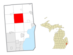
Location within Macomb County
|
|
| Country | |
| State | |
| County | |
| Area | |
| • Total | 36.6 sq mi (95 km2) |
| • Land | 36.5 sq mi (95 km2) |
| • Water | 0.1 sq mi (0.3 km2) |
| Elevation | 650 ft (198 m) |
| Population
(2020)
|
|
| • Total | 3,780 |
| • Density | 103.5/sq mi (40.0/km2) |
| Time zone | UTC-5 (Eastern (EST)) |
| • Summer (DST) | UTC-4 (EDT) |
| ZIP Code |
48096
|
| Area code(s) | 586 |
| FIPS code | 26-67420 |
| GNIS feature ID | 1626955 |
Ray Township is a community located in Macomb County, Michigan, in the United States. It's a type of local government area called a civil township. In 2020, about 3,780 people lived here.
Contents
Exploring Ray Township's Location
Ray Township is found in the northern part of Macomb County. The village of Romeo is right next to its northwest side. The city of Richmond is about 12 miles (19 km) northeast. Mount Clemens, which is the main city of Macomb County, is also 12 miles (19 km) south.
Ray Township's Place in Metro Detroit
Ray Township is part of a larger area called Metro Detroit. This means it's close to the big city of Detroit. Downtown Detroit is about 32 miles (51 km) to the south-southwest.
Land and Water in Ray Township
Ray Township covers a total area of about 36.6 square miles (94.8 km²). Most of this area is land. Only a small part, about 0.1 square miles (0.26 km²), is water. All the water in the township flows into the Clinton River. This river then empties into Lake St. Clair, which is east of Mount Clemens.
Wolcott Mill Metropark: A Local Gem
A large park called Wolcott Mill Metropark is entirely within Ray Township. This park is huge, covering about 2,625 acres (10.6 km²). It's home to the historic Wolcott Mill, which was built way back in 1847. It's a great place for outdoor activities.
Communities Within Ray Township
Ray Township doesn't have any official villages or cities inside it. However, it does have several smaller, unofficial communities. These are places where people live and gather.
Davis: A Historic Community
- Davis was first called Brooklyn. Its name was changed in 1876 to avoid confusion with another Brooklyn in Michigan. Davis is in the southwest part of the township. It's located at Romeo Plank and 27 Mile roads. For many years, Davis was a busy small community. Today, you can find a church, a Masonic Temple, a cemetery, and some local businesses there.
Meade: On the Township Border
- Meade is in the southeast part of Ray Township. It's located right on the border with Macomb Township. You can find it at 26 Mile Road and North Avenue.
Ray Center: In the Heart of the Township
- Ray Center is located east of the middle of the township. It's found at Hartway and 29 Mile roads, west of Indian Trail.
Wolcott Mills: Near the Historic Mill
- Wolcott Mills is another community in the township. It's located at Wolcott Road and Indian Trail. This community is close to the famous Wolcott Mill.
People of Ray Township
Understanding the people who live in Ray Township helps us learn about the community. This section shares information about the population.
Ray Township's Population Count
According to the 2020 census, the total number of people living in Ray Township was 3,780. This number helps us know how many residents call Ray Township home.
Population Changes Over Time
In 2010, the population was 3,739 people. This means the number of residents has stayed pretty similar over the years. There were 1,404 households and 1,112 families living in the township in 2010.
Who Lives in Ray Township?
In 2000, there were 3,740 people living in the township. About 25.7% of the people were under 18 years old. Around 9.4% were 65 years or older. The average age in the township was 39 years old. For every 100 females, there were about 104.7 males.
Family Life and Homes
In 2000, there were 1,305 households in Ray Township. A household is a group of people living together. Most households, about 73.0%, were married couples living together. About 36.9% of households had children under 18 living with them. The average household had about 2.84 people.
Income in Ray Township
In 2000, the average income for a household in Ray Township was $70,081 per year. For families, the average income was $76,880. A small number of families, about 1.4%, were living below the poverty line. This means they had very low incomes.
See also
 In Spanish: Municipio de Ray (Míchigan) para niños


