Dawson Butte facts for kids
Quick facts for kids Dawson Butte |
|
|---|---|

Dawson Butte in winter
|
|
| Highest point | |
| Elevation | 2,278 m (7,474 ft) |
| Prominence | 711 ft (217 m) |
| Isolation | 5.77 mi (9.29 km) |
| Geography | |
| Topo map | USGS Dawson Butte |
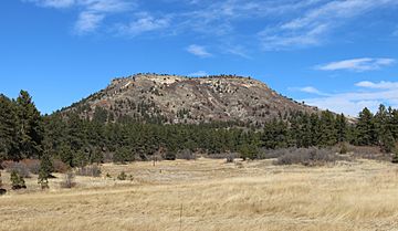
Dawson Butte is a unique, flat-topped mountain in Douglas County, Colorado. It stands tall at about 2,278 meters (7,474 feet) above sea level. Right next to the mountain is the Dawson Butte Open Space. This special area is owned by Douglas County. It is managed by the County's Division of Open Space and Natural Resources.
The mountain and the open space are located about five miles south of Castle Rock.
Contents
Exploring Dawson Butte Open Space
The Dawson Butte Open Space is a fantastic place for outdoor activities. It covers a large area of 828 acres. This means there's plenty of room to explore!
Trails and Activities
A five-mile-long trail winds through the open space. This trail is perfect for many different activities:
- Hikers can enjoy a walk in nature.
- Horseback riders can explore on their horses.
- Snowshoers can visit in the winter.
- Mountain bikers can ride the trails.
If you bring your dog, make sure they are on a leash. There's even an old bridle path on the property. Some of the jumps from this path are still there!
Access to the Butte
While the open space is great for exploring, there is no public access to the very top of Dawson Butte itself.
How Did Dawson Butte Get its Name?
Dawson Butte is named after an early settler in the Plum Creek area, Thomas Dawson. He was one of the first people to live in that region.
A special type of rock formation, called Dawson Arkose, also gets its name from this Butte. This shows how important the Butte was to the area's history and geology.
 | John T. Biggers |
 | Thomas Blackshear |
 | Mark Bradford |
 | Beverly Buchanan |


