Day Boulevard facts for kids

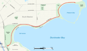
Map of South Boston with Day Boulevard highlighted in red
|
|
| Maintained by | Department of Conservation and Recreation |
|---|---|
| Length | 2.6 mi (4.2 km) |
| Location | Boston, Middlesex County, Massachusetts |
| Coordinates | 42°19′51.18″N 71°01′50.38″W / 42.3308833°N 71.0306611°W |
| West end | Morrissey Boulevard in South Boston |
| East end | Castle Island in South Boston |
William J. Day Boulevard, often called Day Boulevard, is a scenic road in Boston, Massachusetts. It runs along the coast, offering great views of the water. This special road is about 2.6 miles (4.2 km) long. It connects different parts of Boston, like Dorchester and South Boston. It's a popular spot for people to visit the beach and enjoy the outdoors.
The boulevard starts near Morrissey Boulevard. It then curves northeast through South Boston. Along its path, it follows the shores of Dorchester Bay. In its eastern part, the road passes through the South Boston Boat Clubs Historic District. It also goes by Marine Park. The road ends at Castle Island, which has a historic fort and a state park.
The Massachusetts Department of Conservation and Recreation takes care of Day Boulevard. It is part of the larger Metropolitan Park System of Greater Boston. Some popular beaches along Day Boulevard include Carson Beach, M Street Beach, and Pleasure Bay. These beaches are also part of the park system.
History of Day Boulevard
Day Boulevard was first planned a long time ago, in the late 1800s. It was originally known as the Strandway. This road was meant to be the easternmost part of the Emerald Necklace. The Emerald Necklace is a famous system of connected parks and waterways in Boston. It was designed by a well-known landscape architect named Frederick Law Olmsted.
How the Road Got Its Name
Original plans included connecting Franklin Park in Dorchester to Marine Park in South Boston. This connection was supposed to happen through a parkway called Dorchesterway and then the Strandway. However, these plans didn't fully happen as first imagined. The route eventually became known as Columbia Road.
Later, the southern part of Columbia Road was given a new name. It was named William J. Day Boulevard in 1950. This was done to honor William J. Day, a well-liked political figure from South Boston.
Historic Recognition
Day Boulevard is recognized as an important historical site. It is listed on the National Register of Historic Places. This means it's part of a special list of places in the United States that are important to history. It is included as part of the Old Harbor Reservation Parkways.
 | Kyle Baker |
 | Joseph Yoakum |
 | Laura Wheeler Waring |
 | Henry Ossawa Tanner |

