De Kalb, Texas facts for kids
Quick facts for kids
De Kalb, Texas
|
|
|---|---|

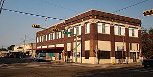
Downtown De Kalb
|
|
| Motto(s):
"Opportunity. Innovation"
|
|

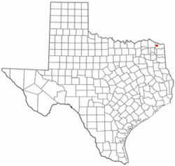
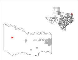
Location of De Kalb, Texas
|
|
 |
|
| Country | United States |
| State | Texas |
| County | Bowie |
| Area | |
| • Total | 1.37 sq mi (3.55 km2) |
| • Land | 1.37 sq mi (3.55 km2) |
| • Water | 0.00 sq mi (0.00 km2) |
| Elevation | 410 ft (120 m) |
| Population
(2020)
|
|
| • Total | 1,527 |
| • Density | 1,163.62/sq mi (449.28/km2) |
| Time zone | UTC-6 (Central (CST)) |
| • Summer (DST) | UTC-5 (CDT) |
| ZIP code |
75559
|
| Area code(s) | 903, 430 |
| FIPS code | 48-19648 |
| GNIS feature ID | 2410303 |
De Kalb is a small city in Bowie County, Texas, United States. It is part of the larger Texarkana metropolitan statistical area. The city uses area codes 430 and 903, and its ZIP code is 75559. De Kalb is in the Central Time Zone. In 2020, about 1,527 people lived there.
Contents
Discovering De Kalb's Past
Key Moments in De Kalb's History
De Kalb has seen some important events over the years. On December 31, 1985, a private plane had an accident near the city. This plane was carrying famous musician Ricky Nelson and his band. It was a very sad event, and many people on board lost their lives. The pilot and co-pilot were able to escape and survived.
Another big event happened on May 4, 1999. An EF-3 tornado directly hit the downtown area of De Kalb. This powerful storm caused a lot of damage to the city center.
Exploring De Kalb's Location
Where is De Kalb Located?
De Kalb is located in Texas. The United States Census Bureau says the city covers about 1.3 square miles (3.5 square kilometers) of land. There is no water area within the city limits.
De Kalb's Climate and Weather
The weather in De Kalb usually features hot and humid summers. Temperatures often reach 100 degrees Fahrenheit (38 degrees Celsius) or more for many days. Winters are generally mild to cool. This type of weather is known as a humid subtropical climate.
Understanding De Kalb's Population
How Many People Live in De Kalb?
The number of people living in De Kalb has changed over time. Here is a look at the population from different years:
| Historical population | |||
|---|---|---|---|
| Census | Pop. | %± | |
| 1890 | 420 | — | |
| 1920 | 910 | — | |
| 1930 | 1,023 | 12.4% | |
| 1940 | 1,287 | 25.8% | |
| 1950 | 1,928 | 49.8% | |
| 1960 | 2,042 | 5.9% | |
| 1970 | 2,197 | 7.6% | |
| 1980 | 2,217 | 0.9% | |
| 1990 | 1,976 | −10.9% | |
| 2000 | 1,769 | −10.5% | |
| 2010 | 1,699 | −4.0% | |
| 2020 | 1,527 | −10.1% | |
| U.S. Decennial Census 1850–1900 1910 1920 1930 1940 1950 1960 1970 1980 1990 2000 2010 |
|||
In 2020, the 2020 United States census counted 1,527 people living in De Kalb. There were 631 households and 362 families. Most people in De Kalb are non-Hispanic white. Black or African Americans make up the second largest group. Hispanic and Latino Americans are also an important part of the community.
In 2000, the average income for a household in De Kalb was $23,713. For families, the average income was $32,212. By 2020, the average household income had increased to $34,178.
Learning in De Kalb
De Kalb's School System
The De Kalb Independent School District serves the city of De Kalb. This is where most children in the area go to school.
Some nearby communities, like Hubbard and Dalby Springs, are south of De Kalb. Many children from these areas also attend the De Kalb ISD schools. However, Hubbard has its own small school district for younger students (Pre-K through 8th grade). Some children choose to attend Hubbard's school during their early years.
Famous Faces from De Kalb
People Who Grew Up in De Kalb
De Kalb is the birthplace of several notable people:
- Dan Blocker was born in De Kalb. He was a famous actor who played "Hoss Cartwright" on the TV show Bonanza.
- Terrance Ganaway is a former NFL running back.
- Al Perkins is a talented musician, singer-songwriter, and producer.
- Timothy Rhea is the Director of Bands and Music Activities at Texas A&M University. He also used to be the president of the American Bandmasters Association. He graduated from De Kalb High School.
- Luke Walker was a pitcher in Major League Baseball. He played for the Pittsburgh Pirates and Detroit Tigers between 1965 and 1974.
Images for kids
See also
 In Spanish: De Kalb (Texas) para niños


