
Deer Island (Marin County) facts for kids

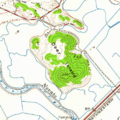
USGS aerial imagery of Deer Island
|
|

Deer Island
Location in San Francisco Bay Area

Deer Island
Location in California

Deer Island
Location in the United States
|
|
| Geography | |
|---|---|
| Location | Northern California |
| Coordinates | 38°05′52″N 122°32′13″W / 38.09778°N 122.53694°W |
| Adjacent bodies of water | Novato Creek |
| Highest elevation | 167 ft (50.9 m) |
| Administration | |
|
United States
|
|
| State | |
| County | Marin |
Deer Island is a special place in Marin County, California. It used to be an island, surrounded by wetlands near Novato Creek. Today, it's known as the Deer Island Preserve. This area is close to San Pablo Bay, which is part of the larger San Francisco Bay.
Contents
What is Deer Island?
Deer Island is a unique natural area in Northern California. It was once an island, meaning it was completely surrounded by water or wetlands. Over time, the land around it changed. The United States Geological Survey (USGS) measured its elevation. In 1981, it was about 167 ft (51 m) above sea level.
Where is Deer Island Located?
This interesting spot is found in Marin County. This county is in the northern part of California. Deer Island sits near Novato Creek, a waterway that flows into San Pablo Bay. San Pablo Bay is a northern arm of the famous San Francisco Bay. Its exact location is 38°05′52″N 122°32′13″W / 38.09778°N 122.53694°W.
Why is Deer Island a Preserve?
Today, Deer Island is a protected area called the Deer Island Preserve. A preserve is a place where nature is kept safe. This means the plants, animals, and natural features are protected. Preserves help keep important habitats healthy. They also allow people to enjoy nature responsibly.
Exploring the Preserve
At Deer Island Preserve, visitors can enjoy the outdoors. It's a great place for activities like hiking and birdwatching. The preserve protects important wetland habitats. These wetlands are home to many different kinds of wildlife.
Importance of Wetlands
Wetlands are areas where water covers the soil. They are very important for the environment. Wetlands act like natural filters, cleaning water. They also provide homes for many animals. Birds, fish, and other creatures depend on healthy wetlands. Protecting places like Deer Island helps keep these ecosystems strong.
Images for kids
-
Deer Island in a USGS topographic map from 1954

