
Deil's Dyke facts for kids

A section of the Deil's Dyke on Dalhanna Hill at New Cumnock
|
|
| Coordinates | NS 8000 0591 to NS 8404 0526 |
|---|---|
| Location | New Cumnock to Durisdeer parish |
| Designer | Unknown |
| Type | Earthwork |
| Material | Earth, stones and turf |
| Length | Up to 16 mi (26 km) |
| Width | 3 m (9.8 ft) |
| Height | 0.7 m (2 ft 4 in) |
| Completion date | Medieval or Iron Age |
The Deil's Dyke (also known as the Pict's Dyke or Celt's Dyke) is a long, old earth wall in south-west Scotland. It's like a big, rounded bank of earth, sometimes with stones inside. This wall is usually about 2 to 4 meters wide and up to 0.7 meters high. Sometimes, it has a small ditch next to it, about 0.5 meters wide and 0.4 meters deep.
This earthwork roughly follows the line where higher grazing lands meet lower farming lands. It's similar to "head-dykes" used in medieval times. However, no one is completely sure what its real purpose was. It doesn't seem strong enough to be a military defense. Its winding path also makes it unlikely to have been a simple political border.
Contents
Where is the Deil's Dyke Located?
The Deil's Dyke isn't one continuous wall. It appears in sections across the landscape. It generally runs from east of Afton Water near New Cumnock to Burnmouth in the Durisdeer area. Along its path, it goes through the parishes of New Cumnock, Kirkconnel, and Sanquhar.
There's also a separate part that runs from the old Durisdeer Castle towards Durisdeer village. The dyke usually follows land contours that are about 150 to 275 meters (500 to 900 feet) above sea level.
What is the History of the Deil's Dyke?
The Deil's Dyke was first written about in 1824 by Chalmers in his book ‘Caledonia’. He mentioned Joseph Train and others for describing what was left of the dyke. In 1841, another report was published in MacKenzie’s ‘History of Galloway’.
Early Theories and Discoveries
People once thought the dyke stretched from Loch Ryan all the way to the Solway Firth. They believed it was a border between the Picts and the Britons of Strathclyde. Some even thought it had a defensive fence, watchtowers, and forts. However, this idea was later found to be wrong. Many of the features included in this long line were actually just old farm boundaries or other unrelated things.
A survey in 1956 suggested that the dyke runs for about 16 miles (26 km). This section goes from near Burnmouth Farm to Dalhanna Hill, near New Cumnock. This part is thought to be a single structure. It was likely built and planned by one main group or authority.
Excavations and Dating
In 1981, archaeologists dug up a section of the dyke. They found it was just an earth bank. It was probably built all at once. The turf used to build it came from both sides of the wall. At its base, it was about 1.4 meters (4.5 feet) wide. Experts think it was originally about 2 meters (6.5 feet) tall. They found some clues from both the late Iron Age and the medieval period. However, these clues didn't give a definite date for when it was built.
Possible Purposes of the Dyke
It's unlikely the dyke was built as a boundary for one person's land. No single landowner controlled such a huge area back then. Instead, it might have been a medieval "head-dyke." This means it separated farming land from grazing land. Another idea is that it was used for a "deer hay wind" or for marking a hunting forest. These ideas fit the evidence better. Many similar earthworks are found nearby, which makes understanding the dyke a bit tricky.
The name 'Deil's Dyke' or 'Devil's Dyke' is often linked to very large structures in old stories. But the name 'Deil's Dyke' can also mean a 'march dyke'. This is a wall that marks a boundary.
Some parts of the dyke might be missing because thick forests used to grow there. Old maps, like one from the 1660s, show large woodlands in Nithsdale. For example, Cashogill Wood was near Enterkinfoot and reached Kilbryd Kirk.
What was the Deil's Dyke Used For?
Local stories say the dyke was used to hide cattle from raiders. Or, it might have slowed down raiders who were stealing sheep, cattle, or horses. This would give people chasing them enough time to catch up.
Head-Dyke Function
In many places, the dyke was used or perhaps even built as a "head-dyke." This type of wall physically separated lower-lying farming land from higher grazing pastures. Sheep and cattle would eat crops if they got into the farming areas. The farming land was called 'in-field,' and the grazing land was 'out-field.' You can often see the difference in the landscape. The 'in-field' areas look green and lush. The 'out-field' areas have more varied colors from rocks, heather, and bracken. As new field boundaries were built, head-dykes became less important. They stopped being used in the 18th and 19th centuries. The dyke's winding path might be because people wanted to include as much good farming land as possible.
Other Possible Uses
The dyke has also been suggested as a boundary between different tribes. Or, it might have been a medieval land boundary. However, its irregular path makes these ideas less likely. The Deil's Dyke isn't usually found near other old defenses. These include Iron Age forts or medieval castles. But, the part of the earthwork near Durisdeer is connected to the site of a medieval castle.
The Catrail in Roxburghshire, southern Scotland, is similar to the Deil's Dyke. It also has a bank and a ditch and runs for about 11.5 miles (18.5 km). The Catrail is thought to be a territorial boundary from the Early Middle Ages. Some once believed it connected to the Deil's Dyke.
Deer Trapping
Some "Deer hay winds" or "elricks" were long banks and ditches. They were used to guide deer for capture. The Deil's Dyke fits this description. Hunting deer left physical marks on the land. These were banks and dykes used as park boundaries or to trap deer.
Surveyed Sections of the Dyke
In 1956, much of the dyke's route was explored. Here are some observations:
- A section near Ardoch Farm (NS 8000 0591 to NS 8260 0515) was removed by farming by 1985.
- In 1978, a part (NS 8000 0591 to NS 8005 0595) was a stone and earth bank, 0.5m high and 4m wide.
- Another section (NS 8020 0601) had a bank that enclosed an area of old farming rows.
- Some parts were hard to follow or had no evidence left.
- A contemporary wall runs along the route of the Dyke near the Glengenny Burn (NS 8150 0591 to NS 8213 0591).
- A clear section (NS 8216 0579 to NS 8272 0535) had a visible bank, 6-9 feet thick and up to 3 feet high, with no ditch.
- Other parts were obscured by modern drains or farm tracks.
- The dyke is thought to have started on the left bank of the Burnsands Burn (NS 8404 0526). This is near where it joins the River Nith.
Old Maps and Place Names
The name Durrysder for Durisdeer was recorded in 1328. In Gaelic, it might mean 'a dark wood of the oak copse'. This fits with a part of the Deil's Dyke ending in a wooded area.
The name 'Deil' can mean 'Devil'. In myths, the Devil and the Picts were often said to build large, unusual structures. But 'Deil' can also be a word for a 'march dyke'. This is a wall that divides or separates things. The name 'Pict's Dyke' is mostly used in the Sanquhar area.
Old maps show that large woodlands once existed in Nithsdale. For example, a map from the 1660s shows Cashogill Wood near Enterkinfoot. It stretched to Kilbryd Kirk. An 1832 map shows a 'Priest Wood' below the old church.
The March Cleugh is a small stream whose name means 'boundary'. It flows from near Kirkbride Hill. A March House stands near the dyke at Burnmouth. The nearby wood is called 'Eliock'. The Gaelic word 'Elerc' originally meant 'ambush'. Later, it meant a 'deer trap'. This was a funnel-shaped area, natural or man-made, where deer were herded to be caught and killed. The name 'Elrick' is linked to these deer traps. A section of the dyke here was recorded in 1920 as having a foundation of large stones. These stones showed it was seven feet wide.
Images for kids
-
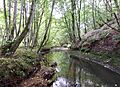
Deer come to drink at sheltered water courses. Old deer traps often started at such points. Animals could be driven from that area along a route leading to their capture.
-
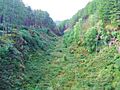
The Glen of the Bar elrick in Galloway is a natural feature once used for managing red deer.


