Delaware River (Texas) facts for kids
Quick facts for kids Delaware River (Texas) |
|
|---|---|

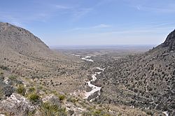
Pine Springs Canyon and the Delaware River (dry) near its source.
|
|
| Country | United States |
| Physical characteristics | |
| Main source | Texas 2,500 metres (8,200 ft) |
| River mouth | New Mexico 865 metres (2,838 ft) |
| Length | c. 80 kilometres (50 mi) |
The Delaware River (Texas) is a special kind of stream. It's an intermittent stream, which means it doesn't always have water flowing in it. It often dries up during parts of the year.
This river starts in Guadalupe Mountains National Park in Texas. This park is in the northwestern part of Culberson County, Texas. The river begins about 8 kilometers (5 miles) west of a place called Pine Springs. It's also about 3 kilometers (2 miles) north of Guadalupe Peak, which is a very tall mountain.
The Delaware River then flows into New Mexico. It joins the Pecos River about 5 kilometers (3 miles) north of the Texas border.
Where Does the Delaware River Flow?
The Delaware River begins in a unique area called a "sky island." This means it's a mountain range that rises like an island above the flat desert around it. This "sky island" is part of Guadalupe Mountains National Park.
As the river flows, it passes through the Chihuahuan Desert. This desert is a very dry place with few people living there. You won't find any big cities or towns along the river.
There are only a few ranches and a small community called Pine Springs nearby. Pine Springs has only about 51 people living there. Most of the land near the river is used for cattle ranching, where cows are raised.
How Did the River Get Its Name?
The Delaware River was named after the Delaware Indians. These Native American people were very important in guiding early American explorers. They helped expeditions, which are journeys for a special purpose, in this area.
One famous expedition was led by Randolph B. Marcy in 1849. The Delaware Indians helped him find his way.
Later, in 1858, a famous mail route called the Butterfield Stage started. This was a stagecoach route that carried mail and passengers across the country. The Butterfield Stage route actually followed the Delaware River for part of its journey.
A special stop, called a stagecoach station, was built at Delaware Springs. This place had several natural springs. Some of these springs had potable water, which means it was safe to drink. Other springs had mineralized water, which means it had minerals dissolved in it. These springs were the only reliable source of water for many miles around.
Images for kids
 | Leon Lynch |
 | Milton P. Webster |
 | Ferdinand Smith |


