
Delaware Route 82 facts for kids
Quick facts for kids
|
||||
|---|---|---|---|---|
| Lua error in Module:Infobox_road/map at line 15: attempt to index field 'wikibase' (a nil value). | ||||
| Route information | ||||
| Maintained by DelDOT | ||||
| Length | 5.51 mi (8.87 km) | |||
| Major junctions | ||||
| South end | ||||
| North end | ||||
| Highway system | ||||
Routes in Delaware
|
||||

Delaware Route 82 (DE 82) is a special road in Delaware. It's called a state highway. This road is in the northwest part of New Castle County, close to the city of Wilmington.
DE 82 is about 5.51 miles (8.87 kilometers) long. It starts near Greenville at DE 52. The road then goes all the way to the border of Pennsylvania. Once it crosses into Pennsylvania, it becomes Pennsylvania Route 82 (PA 82).
This route is very pretty! It goes through areas with lots of trees and open fields. A big part of the road runs right next to the Red Clay Creek. In fact, the entire road is part of something called the Red Clay Valley Scenic Byway. This special byway was created in 2005 because of its beautiful views.
DE 82 got its number way back in 1952. It has been on the same path ever since. In 2010, the Delaware Department of Transportation (DelDOT) thought about taking away the DE 82 signs. But people who lived nearby really liked the road number and wanted to keep it. So, DelDOT decided not to remove the signs.
What the Road Looks Like

DE 82 starts as Campbell Road near Greenville. It heads west from DE 52. This part of the road has two lanes for cars. There is no physical divider between the lanes.
East of DE 52, the road continues as Kirk Road toward DE 100. Along the way, you'll see houses, trees, and open fields. The road also goes over the Hoopes Reservoir. A reservoir is like a big lake that stores water.
After the reservoir, DE 82 turns left onto New London Road. It goes south through many trees. The road makes several turns, heading west at times. You'll pass more fields and homes in a quiet, country area.
Then, DE 82 meets Mt. Cuba Road. Here, DE 82 turns northwest onto Creek Road. This part of the road is very scenic. It runs right next to the Red Clay Creek and the Wilmington and Western Railroad. There are lots of trees along this section.
The road makes more turns and crosses the creek two times. It also crosses the railroad tracks two times. In this area, you can find the Ashland Nature Center.
The route then reaches the small community of Yorklyn. Here, the road briefly turns southwest. It passes a few buildings in this rural area. After Yorklyn, DE 82 turns northwest again onto Creek Road. It continues north next to the Red Clay Creek. The Wilmington and Western Railroad turns away from the road here.
A short distance past Yorklyn, DE 82 reaches the Pennsylvania border. At the border, it changes its name to PA 82. This road then continues toward Kennett Square, Pennsylvania.
Remember, all of DE 82 is part of the Red Clay Valley Scenic Byway. A scenic byway is a special road known for its beautiful views. This byway includes many roads in the Red Clay Creek valley.
History of DE 82
When Delaware first started giving numbers to its state roads in the 1930s, the road that is now DE 82 did not have a number.
By 1952, DE 82 was officially created. It followed the same path it does today. It connected PA 82 in Pennsylvania to DE 52 near Greenville.
In 2005, DE 82 became part of the Red Clay Valley Scenic Byway. This was the second scenic byway created in Delaware.
In 2010, DelDOT, the state's transportation department, had a plan. They thought about removing the DE 82 signs. Their idea was to make the road more about being a scenic byway. However, they held a public meeting to hear what people thought. Many people in the area did not like the plan to remove the signs. They wanted to keep the DE 82 number. So, in April 2010, DelDOT decided to keep the DE 82 signs.
Where the Road Connects
The entire DE 82 route is located in New Castle County.
| Location | Mile | Road | Notes |
|---|---|---|---|
| Greenville | 5.51 | This is the southern end of DE 82. | |
| Yorklyn | 0.00 | This is the Pennsylvania state line and the northern end of DE 82. | |
| 1.000 mi = 1.609 km; 1.000 km = 0.621 mi | |||
Images for kids
-
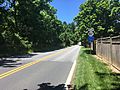
DE 82 going north past its start at DE 52 near Greenville.
-
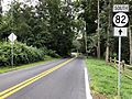
DE 82 going south in Ashland.


