Delhi, Minnesota facts for kids
Quick facts for kids
Delhi, Minnesota
|
|
|---|---|

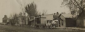
Delhi, Minnesota in 1910
|
|

Cities and townships of Redwood County
|
|
| Country | United States |
| State | Minnesota |
| County | Redwood |
| Settled | 1865 |
| Organized | February 19, 1876 |
| Platted | 1884 |
| Incorporated | November 13, 1902 |
| Area | |
| • Total | 0.761 sq mi (1.970 km2) |
| • Land | 0.761 sq mi (1.970 km2) |
| • Water | 0.000 sq mi (0.000 km2) |
| Elevation | 1,030 ft (314 m) |
| Population
(2020)
|
|
| • Total | 46 |
| • Estimate
(2022)
|
46 |
| • Density | 60.45/sq mi (23.35/km2) |
| Time zone | UTC−6 (Central (CST)) |
| • Summer (DST) | UTC−5 (CDT) |
| ZIP Code |
56283
|
| Area code(s) | 507 |
| FIPS code | 27-15544 |
| GNIS feature ID | 0642755 |
| Sales tax | 7.375% |
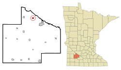
Delhi is a small city in Redwood County, Minnesota, United States. In 2020, the population was 46 people. It is a quiet place with a rich history.
History of Delhi
Delhi was officially planned out in 1884. Its name comes from a place called Delhi in Ohio. A post office opened in Delhi in 1894. It stayed open until 1979.
The Delhi Coronet Band Hall was built in 1896. It was a special place for a community band. Many important social events and political meetings happened there. This building is so important that it is listed on the National Register of Historic Places. On November 25, 1902, people met in the band hall. They decided to make Delhi an official city. The first elections for the city were also held there.
Geography of Delhi
According to the United States Census Bureau, Delhi covers about 0.761 square miles (1.970 square kilometers). All of this area is land. There are no large bodies of water within the city limits.
The main roads in Delhi are County Road 9 and County Road 6. County Road 9 connects Delhi to Belview, which is five miles to the west. County Road 6 links Delhi to Minnesota State Highways 19 and 67. These highways are three miles to the south. The main street that runs east to west is Vanderburg Avenue.
People in Delhi
| Historical population | |||
|---|---|---|---|
| Census | Pop. | %± | |
| 1910 | 159 | — | |
| 1920 | 194 | 22.0% | |
| 1930 | 178 | −8.2% | |
| 1940 | 174 | −2.2% | |
| 1950 | 152 | −12.6% | |
| 1960 | 124 | −18.4% | |
| 1970 | 154 | 24.2% | |
| 1980 | 96 | −37.7% | |
| 1990 | 69 | −28.1% | |
| 2000 | 69 | 0.0% | |
| 2010 | 70 | 1.4% | |
| 2020 | 46 | −34.3% | |
| 2022 (est.) | 46 | −34.3% | |
| U.S. Decennial Census 2020 Census |
|||
Delhi's Population in 2010
In 2010, there were 70 people living in Delhi. These people lived in 31 households. About 19 families made their homes there. The city had about 90 people per square mile.
Most of the people in Delhi (98.6%) were White. A small number (1.4%) were Pacific Islander.
Out of the 31 households, about 19% had children under 18 living with them. More than half (54.8%) were married couples living together. About 6.5% of households had a female head with no husband. Nearly 30% of all households were single individuals. Only 3.2% of these individuals were 65 years old or older and living alone.
The average household had 2.26 people. The average family had 2.84 people. The average age of people in Delhi was 48 years old. About 21.4% of residents were under 18. About 7.1% were 65 or older. The city had slightly more females (51.4%) than males (48.6%).
See also
 In Spanish: Delhi (Minnesota) para niños
 | John T. Biggers |
 | Thomas Blackshear |
 | Mark Bradford |
 | Beverly Buchanan |


