Denair, California facts for kids
Quick facts for kids
Denair
|
|
|---|---|
| Motto(s):
The Oasis of the San Joaquin Valley
|
|

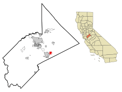
Location in Stanislaus County and the state of California
|
|
| Country | |
| State | |
| County | Stanislaus |
| Area | |
| • Total | 1.64 sq mi (4.25 km2) |
| • Land | 1.64 sq mi (4.25 km2) |
| • Water | 0.00 sq mi (0.00 km2) 0% |
| Elevation | 125 ft (38 m) |
| Population
(2020)
|
|
| • Total | 4,865 |
| • Density | 2,962.85/sq mi (1,143.88/km2) |
| Time zone | UTC-8 (Pacific) |
| • Summer (DST) | UTC-7 (PDT) |
| ZIP code |
95316
|
| Area code | 209 |
| FIPS code | 06-18856 |
| GNIS feature ID | 1655964 |
Denair is a small community in Stanislaus County, California, United States. It's known as a census-designated place (CDP). This means it's a special area defined by the government for counting people, but it's not an official city or town.
In 2020, about 4,865 people lived in Denair. The community is part of the larger Modesto Metropolitan Statistical Area.
Contents
History of Denair
Denair was started in 1904. It grew up along the tracks of the Santa Fe Railroad. This railway was very important for connecting different parts of the country.
The area was first called Elmwood Colony. But it was later renamed Denair. This new name honored a local landowner named John Denair.
Geography and Location
Denair is located in California at these coordinates: 37°31′39″N 120°47′59″W / 37.52750°N 120.79972°W. It's a small place, covering about 2 square miles (5.2 square kilometers) of land. There is no water area within Denair itself.
Denair's Climate
Denair has a special type of weather called a semi-arid climate with Mediterranean influences. This means it has very hot and dry summers. The winters are cool, but not usually freezing cold.
Here's a look at the average weather in Denair:
| Climate data for Denair 3 NNE, California (1899–1984) | |||||||||||||
|---|---|---|---|---|---|---|---|---|---|---|---|---|---|
| Month | Jan | Feb | Mar | Apr | May | Jun | Jul | Aug | Sep | Oct | Nov | Dec | Year |
| Mean daily maximum °F (°C) | 53.4 (11.9) |
60.4 (15.8) |
66.1 (18.9) |
73.1 (22.8) |
81.3 (27.4) |
89.2 (31.8) |
94.9 (34.9) |
92.6 (33.7) |
87.4 (30.8) |
78.1 (25.6) |
65.6 (18.7) |
54.6 (12.6) |
74.7 (23.7) |
| Mean daily minimum °F (°C) | 35.7 (2.1) |
38.6 (3.7) |
40.5 (4.7) |
43.6 (6.4) |
48.6 (9.2) |
53.7 (12.1) |
57.2 (14.0) |
55.8 (13.2) |
52.5 (11.4) |
45.9 (7.7) |
39.0 (3.9) |
35.4 (1.9) |
45.5 (7.5) |
| Average precipitation inches (mm) | 2.23 (57) |
1.98 (50) |
2.00 (51) |
1.09 (28) |
0.39 (9.9) |
0.10 (2.5) |
0.02 (0.51) |
0.04 (1.0) |
0.15 (3.8) |
0.59 (15) |
1.31 (33) |
1.94 (49) |
11.84 (301) |
| Average precipitation days (≥ 0.01 in) | 7 | 7 | 7 | 4 | 2 | 1 | 0 | 0 | 1 | 2 | 5 | 6 | 42 |
| Source: WRCC | |||||||||||||
People of Denair
The number of people living in Denair has grown over the years.
| Historical population | |||
|---|---|---|---|
| Census | Pop. | %± | |
| 2020 | 4,865 | — | |
| U.S. Decennial Census | |||
In 2000, there were 3,446 people. By 2010, the population grew to 4,404. The latest count in 2020 showed 4,865 residents.
Denair in 2010
In 2010, Denair had 4,404 people. Most residents (about 77.8%) were White. About 15.9% were from other races, and 3.5% were from two or more races. People of Hispanic or Latino background made up about 32.3% of the population.
The average age of people in Denair was about 34.8 years old. About 28% of the population was under 18 years old.
See also
 In Spanish: Denair (California) para niños
 | Valerie Thomas |
 | Frederick McKinley Jones |
 | George Edward Alcorn Jr. |
 | Thomas Mensah |

