Denison, Iowa facts for kids
Quick facts for kids
Denison, Iowa
|
|
|---|---|
|
City
|
|

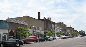
Downtown Denison
|
|

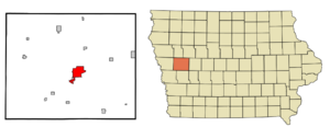
Location of Denison, Iowa
|
|
| Country | USA |
| State | |
| County | Crawford |
| Area | |
| • Total | 6.57 sq mi (17.03 km2) |
| • Land | 6.55 sq mi (16.96 km2) |
| • Water | 0.03 sq mi (0.07 km2) |
| Elevation | 1,257 ft (383 m) |
| Population
(2020)
|
|
| • Total | 8,373 |
| • Density | 1,278.91/sq mi (493.80/km2) |
| Time zone | UTC-6 (Central (CST)) |
| • Summer (DST) | UTC-5 (CDT) |
| ZIP code |
51442
|
| Area code(s) | 712 |
| FIPS code | 19-19945 |
| GNIS feature ID | 2394514 |
Denison is a city in Crawford County, Iowa, in the United States. It is located along the Boyer River. Denison is the main city, also known as the county seat, of Crawford County. In 2020, about 8,373 people lived there.
Contents
History of Denison
Denison was first planned out in 1856. It officially became a city in 1875. The city was named after its founder, a person called J. W. Denison.
Geography and Climate
Denison is located in Iowa. The city covers a total area of about 6.57 square miles (17.03 square kilometers). Most of this area is land, with a very small part being water.
Denison's Climate
Denison has a type of climate called a hot-summer humid continental climate. This means it has warm, humid summers and cold winters. You can find this climate type on maps as "Dfa".
People of Denison
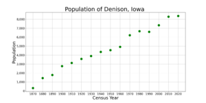
| Historical population | ||
|---|---|---|
| Year | Pop. | ±% |
| 1870 | 326 | — |
| 1880 | 1,441 | +342.0% |
| 1890 | 1,782 | +23.7% |
| 1900 | 2,771 | +55.5% |
| 1910 | 3,133 | +13.1% |
| 1920 | 3,581 | +14.3% |
| 1930 | 3,905 | +9.0% |
| 1940 | 4,361 | +11.7% |
| 1950 | 4,554 | +4.4% |
| 1960 | 4,930 | +8.3% |
| 1970 | 6,218 | +26.1% |
| 1980 | 6,675 | +7.3% |
| 1990 | 6,604 | −1.1% |
| 2000 | 7,339 | +11.1% |
| 2010 | 8,298 | +13.1% |
| 2020 | 8,373 | +0.9% |
| Source: Source: |
||
Denison in 2020
In 2020, there were 8,373 people living in Denison. These people lived in 2,853 households. About 39 out of every 100 households had children under 18 living there.
The people in Denison come from many different backgrounds. About 47.6% were White, 4.2% Black or African American, and 3.2% Asian. A large part of the population, about 49.6%, were Hispanic or Latino.
The average age of people in Denison was 32.1 years old. About 34% of the residents were under 20 years old.
Denison in 2010
Back in 2010, there were 8,298 people living in Denison. The city had 2,816 households at that time.
The mix of people was also diverse. About 70.6% were White, and 23.0% were from other races. About 42.1% of the people were Hispanic or Latino.
The average age in 2010 was 32.6 years. About 29% of the people living there were under 18 years old.
Arts and Culture
Denison has several interesting places that are listed on the National Register of Historic Places. This means they are important historical sites.
Some of these places include:
- Carey House
- Clarence D. Chamberlin House
- Crawford County Courthouse
- Park Motel
- William A. McHenry House
- Yellow Smoke Park Bridge
Education in Denison
The Denison Community School District is in charge of the public schools in the area. This district helps make sure students in Denison get a good education.
Notable People from Denison
Many interesting people have come from Denison. Here are a few:
- Kyle Borland – An NFL player.
- Clarence Duncan Chamberlin – A pioneer in aviation, meaning he was one of the first people to fly planes.
- Chuck Darling – A basketball player who won a gold medal at the 1956 Summer Olympics.
- Jim Garrison – A District Attorney from New Orleans.
- James E. Hansen – He used to lead NASA's Goddard Institute for Space Studies, which studies Earth and space.
- Donna Reed – An actress who won an Academy Award. The Donna Reed Foundation has its main office in Denison.
- Brandon Scherff – An offensive guard for NFL teams like the Washington Commanders and Jacksonville Jaguars.
- L.M. Shaw – He was the 17th Governor of Iowa and also served as the United States Secretary of the Treasury.
Images for kids
See also
 In Spanish: Denison (Iowa) para niños
 | May Edward Chinn |
 | Rebecca Cole |
 | Alexa Canady |
 | Dorothy Lavinia Brown |


