
Boyer River (Iowa) facts for kids
Quick facts for kids Boyer River |
|
|---|---|

The Boyer River at Denison
|
|

This excerpt from the Lewis and Clark map of 1814 that shows the rivers of southwest Iowa, southeast Nebraska, and northwest Missouri. "Bowyer's River" is seen at upper left.
|
|
| Country | US |
| State | Iowa |
| District | Pottawattamie County, Iowa |
| Physical characteristics | |
| Main source | 42°30′05″N 95°16′32″W / 42.5014°N 95.2755°W |
| River mouth | Missouri River 971 ft (296 m) 41°27′11″N 95°55′09″W / 41.4531°N 95.9192°W |
| Length | 118 miles (190 km) |
| Depth |
|
The Boyer River is a river in western Iowa, United States. It is about 118 miles (190 km) long. The Boyer River flows into the larger Missouri River. A river that flows into another river is called a tributary.
The river is named after an early settler. This person hunted and trapped animals in the area. This was even before the famous Lewis and Clark Expedition explored the region.
Many explorers traveled near the mouth of the Boyer River. These included Lewis and Clark, John James Audubon, and Prince Maximilian zu Wied-Neuwied. They used the Missouri River for their journeys.
Today, this area is part of the Boyer Chute National Wildlife Refuge. Long ago, the Boyer River deposited sand and dirt into the Missouri River. This created a sandy island. Over time, the Missouri River cut a new path through this sand. This path became known as Boyer Chute. Explorers and traders often used this chute.
Where Does the Boyer River Flow?
The Boyer River starts near Storm Lake. This is in southwestern Buena Vista County. It first flows south into Sac County.
Then, the river turns southwest. It flows through several counties. These include Crawford, Harrison, and Pottawattamie Counties.
The Boyer River passes by many towns. Some of these towns are Deloit, Denison, Arion, Dow City, Dunlap, Woodbine, Logan, and Missouri Valley.
Finally, the river joins the Missouri River. This happens in northwestern Pottawattamie County. It is about 13 miles (21 km) north of Council Bluffs.
Other Rivers Joining the Boyer
At Denison, the Boyer River collects water from the East Boyer River. The East Boyer River begins in northwestern Carroll County. It flows southwestward past Vail.
In southwestern Harrison County, another river joins the Boyer. This is the Willow River.
Images for kids
-
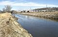
The Boyer River at Denison, Iowa
-
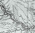
An old map from 1814 showing "Bowyer's River" (Boyer River)
