Missouri Valley, Iowa facts for kids
Quick facts for kids
Missouri Valley, Iowa
|
|
|---|---|
 |
|

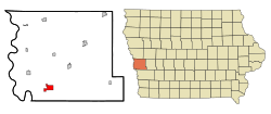
Location of Missouri Valley, Iowa
|
|
| Country | |
| State | |
| County | Harrison |
| Incorporated | October 30, 1871 |
| Area | |
| • Total | 3.36 sq mi (8.71 km2) |
| • Land | 3.36 sq mi (8.71 km2) |
| • Water | 0.00 sq mi (0.00 km2) |
| Elevation | 1,001 ft (305 m) |
| Population
(2020)
|
|
| • Total | 2,678 |
| • Density | 796.43/sq mi (307.50/km2) |
| Time zone | UTC-6 (Central (CST)) |
| • Summer (DST) | UTC-5 (CDT) |
| ZIP code |
51555
|
| Area code(s) | 712 |
| FIPS code | 19-52860 |
| GNIS feature ID | 2395356 |
| Website | http://www.cityofmissourivalley.com |
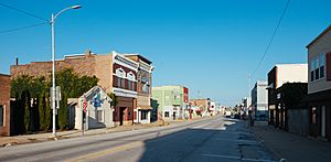
Missouri Valley is a city located in Harrison County, Iowa, United States. In 2020, about 2,678 people lived there.
Contents
History of Missouri Valley
Missouri Valley was first settled in 1856 and was known as St. John's. It was built where three important railroad lines met. These lines were the Chicago & Northwestern, Sioux City & Pacific, and Fremont, Elkhorn & Missouri Valley.
In 1858, the town moved about two miles from its first spot. It was then called "New St. Johns." Soon after, the town was renamed "Missouri Valley." This new name came from the nearby Missouri River valley.
How Railroads Shaped Missouri Valley
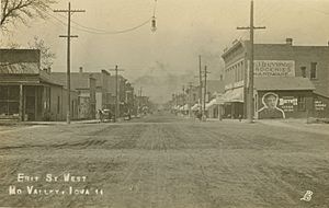
The city of Missouri Valley was officially planned in 1867. This happened when the Chicago and North Western Railway reached the area. In the late 1800s, Missouri Valley was truly a "railroad town."
The Sioux City and Pacific railroad had its main offices there. This brought many jobs, like repair shops, machine shops, and blacksmiths. By 1896, nearly 4,000 people lived in Missouri Valley. About 25 passenger trains arrived and left the city every day.
In 1900, the city decided that railroads were its most important business. They were the main reason the town grew and thrived.
Geography and Location
Missouri Valley covers about 3.13 square miles (8.11 square kilometers) of land. There is no water area within the city limits. The city is located in a unique area of Iowa called the Loess Hills. These hills are made of fine, wind-blown soil.
Population and People
The city's population has changed over the years. In 1880, there were 1,154 people. The population grew to 4,010 by 1900. By 2020, the population was 2,678 people.
Who Lives in Missouri Valley?
In 2020, there were 2,678 people living in Missouri Valley. Most residents, about 93.9%, were White. Other groups included Black or African American, Native American, and Asian people. About 3.4% of the population was Hispanic or Latino.
The average age in the city was 42.1 years old. About 24.2% of residents were under 20 years old. About 21.6% were 65 years or older. There were slightly more females (51.3%) than males (48.7%).
Education in Missouri Valley
Students in Missouri Valley attend schools in the Missouri Valley Community School District. This district serves the city and the nearby rural areas. Some students from Missouri Valley also attend Saint Albert Catholic Schools in Council Bluffs.
Transportation and Roads
Missouri Valley is easy to reach by road. U.S. Route 30 runs through the city. The city is also close to Interstate 29 at exit 75. Two county roads, L20 and F66, also serve the area. L20 runs north and south, and F66 runs east from U.S. 30.
Famous People from Missouri Valley
- Hugh A. Butler (1878–1954) – He was a United States Senator who represented the state of Nebraska.
- Margarita Fischer (1886–1975) – She was a stage actress. She also appeared in over 175 silent movies.
See also
 In Spanish: Missouri Valley (Iowa) para niños
 | Shirley Ann Jackson |
 | Garett Morgan |
 | J. Ernest Wilkins Jr. |
 | Elijah McCoy |


