
Deora, Colorado facts for kids
Quick facts for kids
Deora, Colorado
|
|
|---|---|

Deora, Colorado
Location in Colorado

Deora, Colorado
Location in the United States
|
|
| Country | United States |
| State | Colorado |
| County | Baca County |
| Elevation | 4,672 ft (1,424 m) |
| Time zone | UTC−7 (MST) |
| • Summer (DST) | UTC−6 (MDT) |
| ZIP Code |
81054 Las Animas
|
| Area code | 719 |
| FIPS code | 08-20110 |
| GNIS ID | 196051 |
Deora is a small, quiet community in Baca County, Colorado, United States. It is known as an unincorporated community. This means it does not have its own local government like a city or town. Today, very little remains of the original settlement.
Contents
Discovering Deora: A Look at Its Past
Deora was once a busier place. It had a post office, a school, a store, and a special railway stop.
How Deora Got Its Name
In 1920, a post office was set up in Deora. The person in charge of the post office suggested naming the place de oro. This is a Spanish phrase that means "of gold."
Life in Early Deora
In June 1921, tests for mail carriers were held in Deora. In March 1922, work started on a large post office building. Construction of the building began in August of that year.
A good road was finished in September 1923. This road connected Springfield and Las Animas. It passed right through Deora. A person named J.S. Dockum ran the Deora store during the 1920s.
The school in Deora was called Valley View school. In 1927, the teacher at Deora was studying at Colorado State Teachers College.
The 4-H Club and the Railroad
In 1933, a youth club called 4-H started in Deora. It was named the Big Rock chapter and had 40 members. This 4-H club is still active today. It is the largest 4-H club in Baca County. However, its members now meet in Springfield.
In 1937, the Atchinson, Topeka & Santa Fe Railroad built a train line. This line connected towns in Baca County, including Springfield and Campo. A train stop called Frick was opened about 0.7 miles (1.1 km) north of Deora.
Deora Through the Years
Deora was always a small, rural community. In the 1940s, Deora and other small towns were places where people could sell farm products. They could also buy basic groceries and gasoline. Deora's population stayed small, sometimes as high as 10 people and sometimes as low as 4.
In the 1950s, Deora was still listed in state publications. Its population was 4 people in 1960. The Frick train station was still working in 1963.
In 2007, scientists from the University of Colorado Museum of Natural History studied plants near Deora. They found types of grass like needlegrass, ricegrass, and grama. These plant samples are now kept at the museum.
Deora also gives its name to a special map section. This section is called the Deora quadrangle on a US Geological Survey topographical map.
Where is Deora?
Deora is located about 23 miles (37 km) northwest of Springfield. Springfield is the county seat, which means it is the main town of Baca County. Deora is found north of where County Road 6 and County Road SS meet.
Images for kids
-
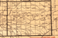
Baca County, Colorado, in 1921. This map shows where Deora and Maxey were located in the northwestern part of the county.

