Derby Parish, New Brunswick facts for kids
Quick facts for kids
Derby
|
|
|---|---|
|
Parish
|
|

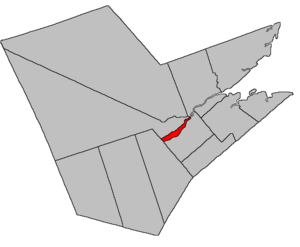
Location within Northumberland County, New Brunswick
|
|
| Country | |
| Province | |
| County | Northumberland |
| Erected | 1859 |
| Area | |
| • Land | 61.00 km2 (23.55 sq mi) |
| Population
(2021)
|
|
| • Total | 938 |
| • Density | 15.4/km2 (40/sq mi) |
| • Change 2016-2021 | |
| • Dwellings | 450 |
| Time zone | UTC-4 (AST) |
| • Summer (DST) | UTC-3 (ADT) |
Derby is a special kind of area in Northumberland County, New Brunswick, Canada. It's called a "civil parish." Think of it like a local district.
Today, Derby is part of the larger community called Miramichi River Valley. This community helps manage local services and is part of the Greater Miramichi Regional Service Commission. Before 2023, Derby was divided into different local service areas.
Contents
Why is it Called Derby?
Derby Parish was named to honor the Earl of Derby. He was the Prime Minister of the United Kingdom when this area was officially created. Some local stories also say it might have been named after horse races held here a long time ago!
A Look at Derby's History
Derby Parish was officially created in 1859. It was formed from a part of Nelson Parish. Specifically, it included all the land north of the Southwest Miramichi River and also Beaubears Island.
Where is Derby Located?
Derby Parish is located in New Brunswick. It has clear boundaries that define its area.
- To the north, its border runs along specific survey lines and land grants.
- To the south, it follows the Southwest Miramichi River.
- To the west, it borders Blackville Parish.
- It also includes Beaubears Island.
How Derby's Borders Changed
Over time, the exact lines of Derby's borders have been adjusted. For example, in 1920, the border with Southesk Parish was changed to follow property lines more closely. Further updates in the 1950s helped create the boundaries we see today.
Communities in Derby
Here are some of the communities you can find in or partly in Derby Parish:
- Bryenton
- Derby
- Derby Junction
- Elmtree
- Lower Derby
- Millerton
- Quarryville
- Upper Derby
Rivers and Islands
Derby Parish is home to some important bodies of water and islands:
Special Places to Visit
There are some interesting parks and historic sites in or near Derby Parish:
- Beaubears Island Shipbuilding National Historic Site of Canada
- Boishébert National Historic Site of Canada
- Wilson's Point Wildlife Refuge
Who Lives in Derby?
Let's look at some facts about the people living in Derby.
Population Changes
The number of people living in Derby has changed over the years.
| Year | Population | Change (%) |
|---|---|---|
| 2016 | 976 | |
| 2011 | 998 | |
| 2006 | 1,068 | |
| 2001 | 1,122 | |
| 1996 | 1,197 | |
| 1991 | 1,221 | N/A |
Languages Spoken
This table shows the main languages people speak at home (their "mother tongue").
| Language | Number of People | Percentage (%) |
|---|---|---|
| English only | 920 | 96.4% |
| French only | 25 | 2.6% |
| Other languages | 10 | 1.0% |
| Both English and French | 0 | 0% |
How to Get to Derby
Here are the main roads and highways that go through Derby Parish:
- Highways
 Route 8
- Principal Routes
 Route 108
- Secondary Routes:
 Route 415
See also
- List of parishes in New Brunswick
 | Delilah Pierce |
 | Gordon Parks |
 | Augusta Savage |
 | Charles Ethan Porter |

