Desaguadero River (Bolivia and Peru) facts for kids
Quick facts for kids Desaguadero |
|
|---|---|

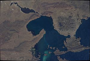
The Desaguadero River at its origin as seen from the ISS (upper center, left; north is to the lower right part of this image)
|
|

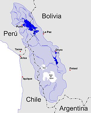
Sketch map of the area showing Desaguadero River
|
|
| Country | Peru, Bolivia |
| Region | Altiplano |
| Cities | Desaguadero, San Andrés, Oruro |
| Physical characteristics | |
| Main source | Lake Titicaca Desaguadero, Peru 3,811 m (12,503 ft) 16°33′49″S 69°02′11″W / 16.56361°S 69.03639°W |
| River mouth | Poopó Lake 50 kilometres (31 mi) S of Oruro, Bolivia 3,686 m (12,093 ft) 18°26′31″S 67°04′22″W / 18.44194°S 67.07278°W |
| Length | 320 km (200 mi) |
| Basin features | |
| Basin size | 90,000 km2 (35,000 sq mi)approx. |
| Tributaries |
|
The Desaguadero River is a very important river located in South America. It flows between two countries: Bolivia and Peru. This river is also sometimes called Risawariru or Uchusumain.
The Desaguadero River starts from the southern part of Lake Titicaca, which is a famous lake high up in the mountains. It then flows south, carrying about five percent of Lake Titicaca's water. This water eventually reaches Lake Uru Uru and Lake Poopó. The river's starting point is very close to the border of Peru.
Contents
What is the Desaguadero River?
The Desaguadero River is a natural waterway that connects Lake Titicaca to other lakes further south. It acts like a drain for Lake Titicaca, helping to manage its water levels. The river is about 320 kilometers (200 miles) long. It flows through the Altiplano, which is a high plateau region in the Andes mountains.
Where does the Desaguadero River start and end?
The river begins at Lake Titicaca, which is located at a very high elevation of about 3,811 meters (12,503 feet) above sea level. This starting point is near the town of Desaguadero, right on the Peru-Bolivia border.
As the river travels south, it loses some elevation. It ends its journey by flowing into Poopó Lake, which is about 50 kilometers (31 miles) south of the city of Oruro in Bolivia. The elevation at Lake Poopó is around 3,686 meters (12,093 feet).
How big is the river's basin?
The area that collects water for the Desaguadero River, known as its basin, is quite large. It covers about 90,000 square kilometers (35,000 square miles). This means a huge amount of land contributes water to this river system.
Life on the Desaguadero River
The Desaguadero River is not just a waterway; it's also a home for many people. It is mostly used by small boats, not large ships. This makes it a peaceful river for local communities.
Who lives along the river?
Many indigenous communities live along the banks of the Desaguadero River. One of these groups is the Uru Muratu community. These communities have lived in this region for a very long time and depend on the river for their daily lives, including fishing and transportation.
What are the river's smaller branches?
The Desaguadero River has several smaller rivers, called tributaries, that flow into it. These tributaries add more water to the main river.
- On the left side, some of the tributaries include:
- Ch'alla Jawira
- Llallawa Jawira
- Jach'a Jawira (Caquiaviri)
- Thujsa Jawira
- Qala Jawira
- Jach'a Jawira (Ingavi)
- On the right side, a notable tributary is:
- Qullpa Jawira
These smaller rivers are important because they bring water from different parts of the basin into the Desaguadero.
See also
 In Spanish: Río Desaguadero (Titicaca) para niños
- Awallamaya Lake
- Desaguadero River (Argentina) from Argentina.

