Devol, Oklahoma facts for kids
Quick facts for kids
Devol, Oklahoma
|
|
|---|---|

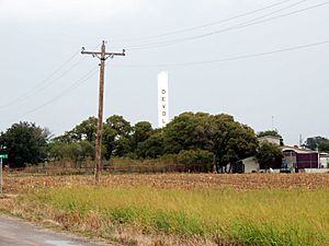
Rural town of Devol, Oklahoma
|
|

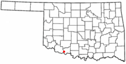
Location of Devol, Oklahoma
|
|
| Country | United States |
| State | Oklahoma |
| County | Cotton |
| Area | |
| • Total | 0.50 sq mi (1.29 km2) |
| • Land | 0.50 sq mi (1.29 km2) |
| • Water | 0.00 sq mi (0.00 km2) |
| Elevation | 1,070 ft (330 m) |
| Population
(2020)
|
|
| • Total | 93 |
| • Density | 186.75/sq mi (72.18/km2) |
| Time zone | UTC-6 (Central (CST)) |
| • Summer (DST) | UTC-5 (CDT) |
| ZIP code |
73531
|
| Area code(s) | 580 |
| FIPS code | 40-20450 |
| GNIS feature ID | 2412422 |
Devol is a small town in Cotton County, Oklahoma, in the United States. In 2020, 93 people lived there. This was a decrease from 150 people in 2000. The town is named after J. Fiske Devol, who owned the land where the town was built.
Contents
History of Devol
Early Days and Growth
The community of Devol started in 1907. This was when the Wichita Falls and Northwestern Railway Company built train tracks through the area. A post office was also opened there on November 30, 1907. By 1911, the town had grown to about 400 residents. The railroad later became part of the Missouri, Kansas and Texas Railroad.
Oil Boom and Decline
In 1918, oil was discovered nearby at the Burkburnett Oil Field. This discovery caused a quick growth period, known as a "boom," for Devol. At least two oil refineries were built in the area. Many oil pipelines were also constructed. By 1920, Devol's population had jumped to 1,936 people. The town even had the first electric generator (dynamo) in the area. It powered one of its two dance halls. Devol had four churches, a lumber store, a feed store, and a hotel. Hundreds of small homes were available for rent during the oil boom.
However, the oil boom ended in 1922. Most people who worked in the oil business moved away. The town's bank failed in 1927. By 1930, Devol's population had dropped significantly to only 328 people. In 1940, there were 208 residents.
After the Boom
A story tells that before World War II, the oil refinery office closed suddenly. The manager and his family left town. After this, the population of Devol dropped by about 1,000 people within a month.
Devol continued to shrink after World War II. Only 152 residents remained in 1950. The high school closed in 1953. By 1957, all school grades were combined with those from Randlett and Union Valley. They formed the Big Pasture School District in Randlett.
In 1959, a tornado hit Devol. It damaged most of the town's businesses and the old high school building. The town's population reached its lowest point, with only 117 residents. The railroad tracks were removed in 1972. By the 1980s, the only business left was a tack shop. This shop made special saddles for race horses. It closed in the 1990s.
Even though the population has slightly increased since then, Devol currently has no businesses. The post office has faced threats of closure in 1997 and 2002. However, it has remained open for over 10 years since then. The town still has a two-cell jail building.
Geography of Devol
Devol is located at 34°11′38″N 98°35′26″W / 34.19389°N 98.59056°W.
The United States Census Bureau states that the town covers a total area of 0.5 square miles (1.29 square kilometers). All of this area is land.
Population Information
| Historical population | |||
|---|---|---|---|
| Census | Pop. | %± | |
| 1920 | 1,936 | — | |
| 1930 | 328 | −83.1% | |
| 1940 | 208 | −36.6% | |
| 1950 | 152 | −26.9% | |
| 1960 | 117 | −23.0% | |
| 1970 | 129 | 10.3% | |
| 1980 | 186 | 44.2% | |
| 1990 | 165 | −11.3% | |
| 2000 | 150 | −9.1% | |
| 2010 | 151 | 0.7% | |
| 2020 | 93 | −38.4% | |
| U.S. Decennial Census | |||
As of the census in 2000, there were 150 people living in Devol. These people lived in 62 households, and 40 of these were families. The population density was about 302 people per square mile (116.7 per square kilometer). There were 68 housing units in the town.
About 90.67% of the people were White. 4.67% were Native American. Another 4.67% were from two or more races. About 8.67% of the population identified as Hispanic or Latino.
In the households, 30.6% had children under 18 living with them. 56.5% were married couples living together. About 8.1% had a female head of household with no husband present. 33.9% of all households were made up of individuals living alone. About 16.1% had someone living alone who was 65 years old or older. The average household size was 2.42 people. The average family size was 3.12 people.
The population was spread out by age. 22.7% were under 18 years old. 10.7% were from 18 to 24. 29.3% were from 25 to 44. 21.3% were from 45 to 64. And 16.0% were 65 years of age or older. The average age was 36 years. For every 100 females, there were about 114.3 males.
The median income for a household in the town was $35,313. For a family, the median income was $46,563. Males had a median income of $23,750, while females had $28,333. The per capita income for the town was $14,792. About 2.1% of families and 9.4% of the total population lived below the poverty line. This included 2.0% of those under eighteen and 36.0% of those over 64.
See also
 In Spanish: Devol (Oklahoma) para niños
 | Madam C. J. Walker |
 | Janet Emerson Bashen |
 | Annie Turnbo Malone |
 | Maggie L. Walker |

