
Dhankuta District facts for kids
Quick facts for kids
Dhankuta
धनकुटा |
|
|---|---|

Location of Dhankuta
|
|
| Country | Nepal |
| Region | Eastern (Purwanchal) |
| Zone | Koshi |
| Headquarters | Dhankuta |
| Area | |
| • Total | 892 km2 (344 sq mi) |
| Population
(2011)
|
|
| • Total | 163,412 |
| • Density | 183.20/km2 (474.48/sq mi) |
| Time zone | UTC+5:45 (NPT) |
| Main language(s) | Nepali, Limbu, Newari, Rai, Tamang, Magar, etc. |
| Website | www.ddcdhankuta.gov.np |
Dhankuta is a district located in the eastern part of Nepal. It is known for its beautiful hills and green landscapes. The main town and administrative center of the district is also called Dhankuta. This district is part of the Eastern development region and the Koshi Zone.
Contents
About Dhankuta District
Dhankuta District is a place where many different groups of people live together. It covers an area of 892 square kilometers. In 2011, about 163,412 people lived here. The main language spoken is Nepali, but you can also hear other languages like Limbu, Newari, Rai, Tamang, and Magar.
What is Dhankuta Like?
Dhankuta is mostly hilly, with many small mountains and valleys. The climate here is usually mild, which means it's not too hot or too cold. This makes it a good place for farming. People in Dhankuta grow different crops, including oranges and tea. The district is also known for its natural beauty and peaceful environment.
How Dhankuta is Organized
Like other districts in Nepal, Dhankuta is divided into smaller parts to help manage it better. These smaller parts include municipalities (like towns) and village development committees (VDCs). Each of these areas has its own local government that works to improve the lives of the people living there. They help with things like building roads, schools, and health centers.
Related pages
Images for kids
-
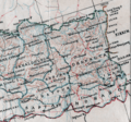
This cropped map of Eastern Nepal (1942) showing large Dhankuta district
-
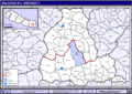
Map showing the different Village Development Committees (VDCs) in Dhankuta District.


See also
 In Spanish: Distrito de Dhankuta para niños
