Eastern Development Region, Nepal facts for kids
Quick facts for kids Eastern Development Region (पुर्वाञ्चल - Purvāñcala) |
|
| Region | |
|
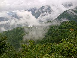
Dhankuta in rainy season
|
|
| Country | |
|---|---|
| Zones | Kosi, Mechi, Sagarmatha |
| Headquarters | Dhankuta |
| Highest point | Mount Everest |
| - elevation | 8,848 m (29,029 ft) |
| - coordinates | 27°59′17″N 86°55′31″E / 27.98806°N 86.92528°E |
| Lowest point | Kechana Kalan |
| - elevation | 60 m (197 ft) |
| - coordinates | 26°22′05″N 88°00′46″E / 26.36806°N 88.01278°E |
| Area | 28,456 km² (10,987 sq mi) |
| Population | 5,811,555 (2011) |
| Density | 204 /km² (528 /sq mi) |
| Timezone | NPT (UTC+5:45) |
| ISO 3166-2 | NP-4 |
The Eastern Development Region (also called Purvāñcala in Nepali) was one of Nepal's five main areas for development. It was located in the eastern part of the country. Its main office, or headquarters, was in the city of Dhankuta.
Contents
Where is the Eastern Region?
The Eastern Development Region was located in a very interesting spot. To its east, it shared borders with Sikkim and West Bengal in India. To the south, it was next to Bihar, also in India.
On its western side, it bordered Nepal's Central Development Region. And to the north, it touched the Tibet Autonomous Region in China.
Size and Population
This region was the third largest development region in Nepal. It covered an area of about 28,456 square kilometers (10,987 square miles).
Even though it was third in size, it was the second most populated region. In 2011, about 5,811,555 people lived there. This meant that about 21.9% of Nepal's total population lived in this region.
The population density was about 204 people per square kilometer. This tells us how many people lived in each square kilometer of land.
Different Landscapes
The Eastern Development Region had three main types of natural areas, called ecological zones:
- The high mountains: These are very tall mountain ranges.
- The hills: These are smaller mountains and rolling landscapes.
- The Terai: This is a flat, fertile plain in the southern part.
Highest and Lowest Points
This region was home to some amazing natural features. The highest mountain in the world, Mount Everest, is located here. It stands tall in the Solukhumbu District, which is part of the Sagarmatha Zone.
The lowest point in all of Nepal is also found in this region. It's called Kechana Kalan and is in the Jhapa district. This spot is very close to the Mechi river and the border with India.
Important Rivers and Waterfalls
The Eastern Development Region has some very important rivers. The Kosi river is a major one. It is a tributary of the famous Ganges river.
Another important river is the Mechi, which flows into the Mahananda River. Nepal's largest river system, the Kosi, is found here.
You can also find Nepal's highest waterfall, called the Hyatrung waterfall, in the Terhathum district. This waterfall is about 365 meters (1,198 feet) high!
Rich Biodiversity
This region is very rich in different kinds of plants and animals, which is called biodiversity. For example, in the Tinjure-Milke-Jaljale area, you can find 28 different species of Rhododendron flowers. Nepal has 31 species in total, so most of them are found right here!
Major Cities and Towns
The Eastern Development Region had several important cities and towns. Some of the major cities included:
- Biratnagar
- Dharan
- Dhankuta
- Itahari
- Rajbiraj
- Birtamod
- Urlabari
- Damak
Other notable places that are well-known include Namche Bazaar. This town is famous because it's near the base camp of Mt. Everest, a popular starting point for climbers. Other towns are Gaighat, Lahan, and Ilam.
How the Region Was Divided
The Eastern Development Region was divided into smaller parts for easier management. It had three main Zones. These zones were arranged side-by-side, almost like parallel lines.
Inside these three zones, there were a total of 16 Districts. There were also 893 Village Development Committees (VDCs), which are like small local governments. The region also had 1 Sub-metropolitan city and 13 Municipalities.
Here's a look at the zones and the districts within them:
| Zone | Population (2011) |
Area (km²) |
Pop. density (inh/km²) |
Districts | |
|---|---|---|---|---|---|
| Number | Names | ||||
| Kosi | 2,335,047 | 9,669 | 241.5 | 6 | Bhojpur, Dhankuta, Morang, Sankhuwasabha, Sunsari, Terhathum |
| Mechi | 1,422,182 | 8,196 | 173.5 | 4 | Ilam, Jhapa, Panchthar, Taplejung |
| Sagarmatha | 2,054,326 | 10,591 | 194.0 | 6 | Khotang, Okhaldhunga, Saptari, Siraha, Solukhumbu, Udayapur |
| Total | 5,811,555 | 28,456 | 204.2 | 16 | |
Learn More
 | Jewel Prestage |
 | Ella Baker |
 | Fannie Lou Hamer |


