Dhar district, India facts for kids
Dhar district is a part of the Madhya Pradesh state in central India. Its main town, also called Dhar, is where the district's administration is located. This district is known for its rich history and interesting geography.
The district covers an area of about 8,153 square kilometers. It shares its borders with several other districts like Ratlam to the north and Indore to the east. In 2011, the population of Dhar district was 2,185,793 people. Pithampur is a big industrial area within Dhar District, and Kukshi is the largest area (called a tehsil) in the district.
Quick facts for kids
Dhar district
|
|
|---|---|
|
District of Madhya Pradesh
|
|
|
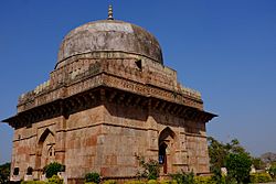
Clockwise from top-left: Jahaz Mahal at Mandu, Bagh Caves, Dhar Fort, Chhapan Mahal, Bhojshala
|
|

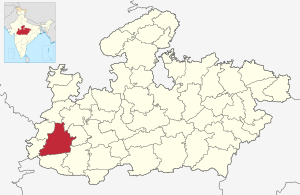
Location of Dhar district in Madhya Pradesh
|
|
| Country | |
| State | Madhya Pradesh |
| Division | Indore |
| Headquarters | Dhar |
| Area | |
| • Total | 8,153 km2 (3,148 sq mi) |
| Population
(2011)
|
|
| • Total | 2,185,793 |
| • Density | 268.097/km2 (694.37/sq mi) |
| Demographics | |
| • Literacy | 60.57 per cent |
| • Sex ratio | 961 |
| Time zone | UTC+05:30 (IST) |
Contents
Geography of Dhar District
The Vindhya Range of mountains runs through the district from east to west. The northern part of Dhar district is located on a high flat land called the Malwa plateau.
Rivers in the District
The northwestern part of the district has rivers that flow into the Mahi River. The northeastern part has rivers that flow into the Chambal River. The Chambal River eventually joins the Ganges river through the Yamuna River. South of the Vindhya mountains, the rivers flow into the Narmada River. The Narmada River also forms the southern border of the district.
How Dhar District is Organized
Dhar district is split into 6 main parts called sub-divisions. These are Dhar, Sardarpur, Badnawar, Manawar, Kukshi, and Dharampuri.
Tehsils and Constituencies
These sub-divisions are further divided into 8 smaller areas called tehsils. These tehsils are Dhar, Badnawar, Dharampuri, Sardarpur, Manawar, Kukshi, Dahi, and Gandhwani. For elections, there are seven areas called Vidhan Sabha constituencies in the district. All these constituencies are part of the single Lok Sabha constituency for Dhar district.
People and Languages of Dhar District
In 2011, the population of Dhar District was 2,185,793. This number grew by about 25.53% from 2001 to 2011.
Population Details
The district has about 961 females for every 1000 males. The literacy rate, which is the percentage of people who can read and write, was 60.57%. About 18.90% of the people live in cities. Special groups of people called Scheduled Castes and Scheduled Tribes make up a significant part of the population.
| Historical population | ||
|---|---|---|
| Year | Pop. | ±% p.a. |
| 1901 | 293,103 | — |
| 1911 | 343,256 | +1.59% |
| 1921 | 393,577 | +1.38% |
| 1931 | 432,482 | +0.95% |
| 1941 | 473,721 | +0.91% |
| 1951 | 503,965 | +0.62% |
| 1961 | 643,774 | +2.48% |
| 1971 | 842,400 | +2.73% |
| 1981 | 1,057,469 | +2.30% |
| 1991 | 1,367,412 | +2.60% |
| 2001 | 1,740,329 | +2.44% |
| 2011 | 2,185,793 | +2.31% |
| source: | ||
Religions and Languages
Most people in Dhar district follow Hinduism, making up about 93.84% of the population in 2011. Islam is the second largest religion.
| Religions in Dhar district (2011) | ||||
|---|---|---|---|---|
| Religion | Percent | |||
| Hinduism | 93.84% | |||
| Islam | 5.31% | |||
| Jainism | 0.56% | |||
| Other or not stated | 0.29% | |||
Many different languages are spoken in the district. In 2011, the most common language was Hindi, spoken by 51.28% of the people. Other languages include Malvi, Nimadi, Bhili, and Bhilali.
Languages of Dhar district (2011) Hindi (51.28%) Malvi (15.62%) Nimadi (15.29%) Bhili (11.49%) Bhilali (3.87%) Others (2.45%)
See also
 In Spanish: Distrito de Dhar para niños
 | Selma Burke |
 | Pauline Powell Burns |
 | Frederick J. Brown |
 | Robert Blackburn |


