
Dicks Creek (Chestatee River tributary) facts for kids

Dicks Creek is a stream located in the state of Georgia, in the United States. It's like a smaller river that flows into a bigger one called the Chestatee River. Dicks Creek is about 7.37 miles (or 11.86 kilometers) long.
Where Dicks Creek Starts and Flows
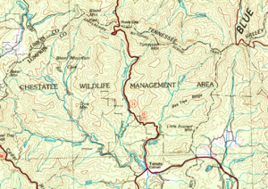
Dicks Creek begins high up in the Blood Mountain Wilderness. This area is part of the Chattahoochee-Oconee National Forest in Lumpkin County, Georgia. It starts just southwest of a mountain called Blood Mountain.
From its start, the creek flows south for about 2.3 miles. Along the way, it meets another small stream called Lance Creek, which joins it from the west. Soon after, Blood Mountain Creek, which flows alongside Dicks Creek, also joins in.
Dicks Creek continues its journey, picking up Miller Creek from the west after another 0.8 miles. Then, it turns southeast and meets Waters Creek, also from the west. Finally, it flows east for 2.8 miles.
Meeting Frogtown Creek

Dicks Creek eventually meets Frogtown Creek. This meeting point is very important because it's where the Chestatee River officially begins! This special spot is near where State Route 9 and U.S. Route 129 cross paths at a place called Turners Corner.
Frogtown Creek starts to the east of Dicks Creek and Blood Mountain Creek. It flows parallel to Dicks Creek and runs next to U.S. Route 19 before joining Dicks Creek. Frogtown Creek is also home to the amazing DeSoto Falls, which you can visit in the Desoto Falls Scenic Area.
What is a Watershed?
The area that Dicks Creek and its connected streams drain is called a watershed. Think of it like a big bowl where all the rain and water flow down into the creek. The Dicks Creek watershed covers about 32 square miles. This area is located east of a town called Suches and north of the Chestatee River.
