Dodgingtown, Connecticut facts for kids
Quick facts for kids
Dodgingtown, Connecticut
|
|
|---|---|

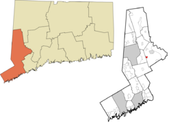
Location within the Western Connecticut Planning Region and the state of Connecticut
|
|
| Country | |
| State | Connecticut |
| County | Fairfield |
| Town | Newtown |
| Area | |
| • Total | 1.11 km2 (0.43 sq mi) |
| • Land | 1.11 km2 (0.43 sq mi) |
| • Water | 0.0 km2 (0 sq mi) |
| Elevation | 160 m (510 ft) |
| Time zone | UTC-5 (Eastern (EST)) |
| • Summer (DST) | UTC-4 (EDT) |
| ZIP Code |
06470 (Newtown)
|
| Area code(s) | 203/475 |
| FIPS code | 09-20250 |
| GNIS feature ID | 2805940 |
Dodgingtown is a small community located in the state of Connecticut, in the United States. It is not a separate town but rather a special area within the larger town of Newtown. This type of area is called a census-designated place (CDP).
What is a Census-Designated Place?
A census-designated place, or CDP, is an area that looks like a town or village. However, it doesn't have its own local government. The United States Census Bureau defines these areas. They do this to collect information about people living there. This helps with statistics and planning.
Where is Dodgingtown Located?
Dodgingtown is found on the western side of Newtown. It is part of Fairfield County. To its west, Dodgingtown shares a border with the town of Bethel. A main road, Connecticut Route 302, goes right through the middle of the community.
A Bit About Dodgingtown's History
Dodgingtown was first officially recognized as a CDP before the 2020 census. A census is like a big count of all the people. The government does this every ten years. It helps them understand how many people live in different areas. This information is important for many things, like planning schools and roads.
 | Sharif Bey |
 | Hale Woodruff |
 | Richmond Barthé |
 | Purvis Young |


