Donnington Wood Canal facts for kids
Quick facts for kids Donnington Wood Canal |
|
|---|---|

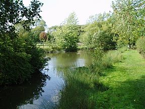
The basin at the foot of the Lilleshall incline now serves as a pond
|
|
| Specifications | |
| Locks | 7 + 1 inclined plane |
| Status | parts still traceable |
| History | |
| Date of act | Privately built |
| Date of first use | 1767 |
| Date closed | 1904 |
| Geography | |
| Start point | Pave Lane |
| End point | Donnington Wood |
| Connects to | Wombridge Canal, Shropshire Canal |
The Donnington Wood Canal was a private waterway in Shropshire, England. It was about 5.5 miles (8.9 km) long. This canal was built to move coal from mines owned by Earl Gower at Donnington Wood. It ended at Pave Lane, where the coal was sold.
The canal opened around 1767 and stopped being used in 1904. It was part of a bigger system of canals that used special small boats called tub-boats. These canals helped transport heavy materials like coal, limestone, and iron ore. These materials were moved from where they were dug up to factories where iron was made. The Donnington Wood Canal also connected to the Wombridge Canal and the Shropshire Canal.
Contents
History of the Canal
Building the Canal
Lord Gower owned coal mines and limestone quarries in Shropshire. He saw how useful canals were for moving heavy goods. His brother-in-law, the Duke of Bridgewater, had already built a famous canal.
In 1764, Lord Gower started a company called Earl Gower & Company. He teamed up with John and Thomas Gilbert. They planned to build a private canal from Lord Gower's coal mines in Donnington Wood. The canal would go to Pave Lane, near the main road to Newport. Here, the coal would be sold.
Work on the canal began in February 1765. About 30 men were hired for the job. They earned between 3.5 old pence and 1 shilling a day. The main part of the canal, which was 5.5 miles (8.9 km) long, was finished by late 1767. All the building work was done by July 1768. There are signs that boats could even go right into the mines to pick up coal!
Lord Gower became the first Marquis of Stafford in 1786. His son, George Leveson-Gower, took over in 1803. He later became the Duke of Sutherland in 1833. Because these important men owned the canal, it was sometimes called the Marquis of Stafford's Canal or the Duke of Sutherland's Canal.
Branch Lines and Connections
The canal had a special branch line that went to the limestone quarries at Lilleshall. This branch met the main canal at Hugh's Bridge. The Lilleshall branch was about 42.7 feet (13.0 m) lower than the main canal.
At first, a tunnel was built into the hill with vertical shafts. A pulley system helped move coal down to the lower level. This coal was used to make lime for farms. Limestone was pulled up to the top level for making iron. By 1797, this system was replaced by an inclined plane. This was like a ramp, 123 yards (112 m) long, powered by a steam engine. It moved wagons loaded with goods between the two levels, but it never carried boats.
The Lilleshall Branch also went to the Pitchcroft limeworks. This part had two short arms to other parts of the Lilleshall limeworks. The Pitchcroft limeworks were 35 feet (11 m) lower than the main canal. So, seven locks were built to help boats go up and down.
New iron furnaces were built at Donnington Wood in 1785. After this, much of the limestone was sent to these new furnaces. The canal connected to the Wombridge Canal in 1788 and the Shropshire Canal in 1790. Both connections were at Old Yard Junction. In 1794, the Wombridge Canal became part of the Shrewsbury Canal. In 1825, new furnaces were built at Old Lodge, Donnington Wood. A new arm was built to connect them to the main canal.
Water Supply
Most of the canal's water came from the Donnington Wood coal mines. There were several large pumping engines at the mines and at Muxton Bridge. These engines worked until the late 1920s. Limekiln Pool and Willmer Pool supplied water for the Lilleshall Branch.
The areas around Donnington Wood had many mining operations. About 74 mine shafts were dug between 1818 and 1835. In 1870, the Lilleshall Company had 15 pumping engines working. These engines lifted water from depths of 150 feet (46 m) to 600 feet (180 m). They pumped out 20,000 tons of water each month!
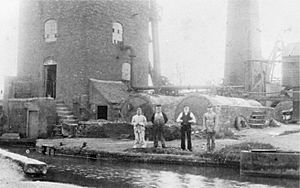
One of these, Steven's Pit, started before 1830. It pumped water from 570 feet (170 m deep). In 1870, its engine had a large 52-inch (130 cm) cylinder. This engine kept working until February 6, 1928, providing water to the canal. It was taken apart soon after. Once the pumping stopped, the western end of the canal dried up.
Why the Canal Closed
After 1844, less traffic used the Lilleshall branch. This was because the Shrewsbury Canal offered a better way for the Lilleshall Company to connect to the canal network. The Lilleshall limeworks closed in the 1870s. This meant the Lilleshall branch was no longer used.
As a result, the section of the canal to Pave Lane was used very little. It finally closed in 1882. The Old Lodge furnace arm stopped being used in 1888 when the furnaces closed. Soon after, part of the Pave Lane section was used to build a road for carriages. This road led to Lilleshall Hall, which was owned by the Duke of Sutherland. The last part of the canal, about 1.2 miles (1.9 km) long, was used until it was finally abandoned in 1904.
What were Tub-Boats?
The boats used on this canal were called tub-boats. They were about 20 feet (6.1 m) long and 6 feet 4 inches (1.9 m) wide. Each tub-boat could carry up to 8 tons of cargo.
These boats were usually linked together in "trains" and pulled by a single horse. A train could have up to twelve tub-boats when carrying heavy coal. This meant one horse could pull about 60 tons of coal! If the cargo was lighter, like limestone, a horse could pull up to 20 tub-boats. A person on the towpath would use a long pole to help steer the boats.
Where the Canal Ran
The Donnington Wood Canal generally ran from the south-west to the north-east. For most of its path, it followed the 330-foot (100 m) contour line. The Lilleshall and Pitchcroft branches were north of the main canal.
Main Route Today
The place where the canal ended at Pave Lane is now covered by farm buildings. If you go further, you can still see the bridge that carried Pitchcroft Lane over the canal. The old canal bed and towpath are clearly visible there.
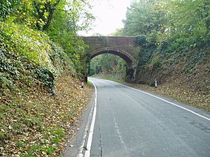
Part of the canal bed is now a carriage drive to Lilleshall Hall. This hall is now a National Sports Centre. The access road follows the old canal route. It goes through a cutting under Little Hales Bridge. This bridge once carried a track from Little Hales Manor Farm over the canal. A little further on, the canal turned west. There's a section of the canal bed in the woods that often still holds water.
You can see the canal's path again at Incline Plantation. There's a large basin (a wide part of the canal) at the top of the incline. A road called The Incline runs along the old towpath to Hugh's Bridge. This bridge carries a small road over the canal. The canal then ran south to the remains of Lilleshall Abbey, going around its east side. It then turned south-east to go under Lilyhurst Road at Abbey Bridge.
After passing Abbey Farm, it crossed more fields and reached the edge of Muxton. Some parts of the canal are now inside a golf course, and some sections still have water. It then runs along the edge of Granville Nature Reserve and into Granville Country Park. It's hard to follow the route here because many railway lines also crossed the area. The park has also been changed a lot.
The Old Lodge basin and parts of the old furnaces are near the main road into the park. Some work was done in 1988 to fix them up. This included rebuilding the wharf, removing trees, and cleaning out the basin. However, it's hard to imagine the arm that connected to the canal. This is because mining waste has raised the ground level so much. Beyond the A4640 road, all signs of the canal have been covered by new buildings. The end basin and where it joined the Wombridge Canal and Shropshire Canal were near where the modern Council Offices are now.
Branch Lines Today
The Lilleshall Branch went down an incline near Hugh's Bridge. Its grassy slope is still easy to see. The basin at the bottom of this incline is now a pond. You can still see the top of the tunnel that met the vertical shafts. From the incline, the canal bed towards the Lilleshall Limeworks is clear for most of its length.
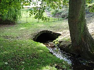
The southern entrance of the bridge that carried Willmoor Lane over the canal is still visible. It's hidden by plants. The northern side of the bridge has been taken down, and the path widened with rubble. The branch to Pitchcroft Limeworks is not easy to find. However, the field boundaries show its route for most of the way. A section of the canal bed is visible near the cottages at Pitchcroft. There are some remains of the bridge, but the basin beyond the road has disappeared.
Old maps from 1888 show only one branch from the Pitchcroft Branch to the Lilleshall Limeworks. The main Lilleshall Branch was still shown as a canal. But the Pitchcroft Branch and its arm were marked as "disused" (no longer used). The locations of three locks near the junction can be seen. However, the other four locks are not clear on the map from that time.
Points of Interest
| Point | Coordinates (Links to map resources) |
OS Grid Ref | Notes |
|---|---|---|---|
| Pave Lane wharf | 52°44′47″N 2°21′27″W / 52.7463°N 2.3574°W | SJ759165 | |
| Pitchcroft Lane bridge | 52°44′39″N 2°21′48″W / 52.7441°N 2.3634°W | SJ755163 | |
| Little Hales bridge | 52°44′29″N 2°22′08″W / 52.7415°N 2.3688°W | SJ751160 | |
| Lilleshall Branch junction | 52°43′59″N 2°23′11″W / 52.7330°N 2.3863°W | SJ740151 | Top of incline |
| Abbey Bridge | 52°43′24″N 2°23′32″W / 52.7233°N 2.3921°W | SJ736140 | By Lilleshall Abbey |
| Section in Muxton Golf Course | 52°42′55″N 2°24′31″W / 52.7152°N 2.4086°W | SJ724131 | |
| Steven's Engine | 52°42′39″N 2°25′48″W / 52.7107°N 2.4299°W | SJ710126 | |
| Old Forge basin | 52°42′29″N 2°25′10″W / 52.7080°N 2.4194°W | SJ717123 | |
| Terminal wharf | 52°42′36″N 2°26′06″W / 52.7101°N 2.4349°W | SJ707125 | Jn with Wombridge Canal |
| Willmore Bridge | 52°44′21″N 2°23′33″W / 52.7393°N 2.3924°W | SJ736158 | Jn with Pitchcroft Arm |
| Lilleshall Basin | 52°44′37″N 2°23′42″W / 52.7436°N 2.3949°W | SJ734162 | End of Lilleshall Branch |
| Arm to Lilleshall Limeworks | 52°44′32″N 2°23′23″W / 52.7422°N 2.3896°W | SJ737161 | from Pitchcroft Arm |
| Pitchcroft Basin | 52°45′03″N 2°23′15″W / 52.7508°N 2.3876°W | SJ739170 | End of Pitchcroft Arm |
 | John T. Biggers |
 | Thomas Blackshear |
 | Mark Bradford |
 | Beverly Buchanan |


