
Dorado barrio-pueblo facts for kids
Quick facts for kids
Dorado barrio-pueblo
Pueblo de Dorado
|
|
|---|---|
|
Municipality Seat
|
|

Town Hall in Dorado barrio-pueblo
|
|

Location of Dorado barrio-pueblo within the municipality of Dorado shown in red
|
|

Dorado barrio-pueblo
Location in Caribbean
|
|
| Commonwealth | |
| Municipality | |
| Area | |
| • Total | 0.07 sq mi (0.2 km2) |
| • Land | 0.07 sq mi (0.2 km2) |
| • Water | 0 sq mi (0 km2) |
| Elevation | 52 ft (16 m) |
| Population
(2010)
|
|
| • Total | 780 |
| • Density | 11,142.9/sq mi (4,302.3/km2) |
| Source: 2000 Census | |
| ZIP Code |
00646
|
Dorado barrio-pueblo is a special part of Dorado, a town in Puerto Rico. It's like the main downtown area or the "seat" of the Dorado municipality. In 2010, about 780 people lived here.
Dorado barrio-pueblo is one of six main areas, called barrios, in the municipality of Dorado. The other barrios are Espinosa, Higuillar, Maguayo, Mameyal, and Río Lajas.
Just like in Spain, towns in Puerto Rico often have a central area called a pueblo. This pueblo usually has a main square (or plaza), important government buildings like the city hall, and a Catholic church. Every year, special festivals called Fiestas patronales are held in the central plaza to honor the town's patron saint.
| Historical population | |||
|---|---|---|---|
| Census | Pop. | %± | |
| 1900 | 937 | — | |
| 1910 | 946 | 1.0% | |
| 1920 | 1,163 | 22.9% | |
| 1930 | 2,053 | 76.5% | |
| 1940 | 2,211 | 7.7% | |
| 1950 | 2,537 | 14.7% | |
| 1980 | 1,347 | — | |
| 1990 | 1,081 | −19.7% | |
| 2000 | 994 | −8.0% | |
| 2010 | 780 | −21.5% | |
| U.S. Decennial Census 1899 (shown as 1900) 1910-1930 1930-1950 1980-2000 2010 |
|||
Contents
The Heart of Dorado: Plaza and Church
The central plaza, or town square, is a lively place in Dorado barrio-pueblo. It's used for both official events and just for fun. People gather here from morning until night to relax and socialize.
Old Spanish laws, called the Laws of the Indies, guided how towns in Puerto Rico were built in the early 1800s. These laws said that the plaza should be big enough for celebrations and for all the people living nearby. They also suggested that the streets around the plaza should have comfortable walkways. These walkways would protect people from the sun and rain.
Right across from the central plaza in Dorado barrio-pueblo is the Parroquia San Antonio de Padua. This Catholic church is named after Saint Anthony of Padua, a Portuguese priest. The church was built over many years, from 1826 until July 1848.
A Glimpse into History
After the Spanish–American War, Spain gave Puerto Rico to the United States in 1898. This happened under an agreement called the Treaty of Paris of 1898. Puerto Rico then became a territory of the United States.
In 1899, the United States Department of War counted the population of Puerto Rico. They found that 937 people lived in Dorado Pueblo at that time.
More recently, in July 2020, the Federal Emergency Management Agency (FEMA) provided money. These funds were for making repairs to Dorado's central plaza.
Understanding Local Areas: Sectors
In Puerto Rico, barrios are often divided into even smaller local areas. These smaller units are called sectores (which means sectors in English). The names for these sectors can be different. Some are simply called sector, while others might be named urbanización, reparto, barriada, or residencial.
Here are some of the sectors you can find in Dorado barrio-pueblo:
- Barriada San Antonio
- Residencial Manuel Morales
- Sector Finca Santa Bárbara
- Sector Juan Francisco
- Sector La Julia
- Sector Mameyal Playa (a part of PR-165)
- Urbanización Brisas de Plata (which used to be called Villa Caíto)
- Urbanización Jardines de Dorado
- Urbanización Martorell
- Urbanización Sabanera Dorado
Dorado barrio-pueblo is also part of the larger urban area of Dorado.
Gallery
Places in Dorado barrio-pueblo:
-
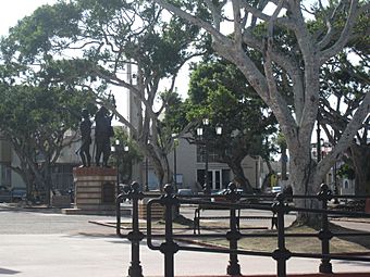
The main plaza
-
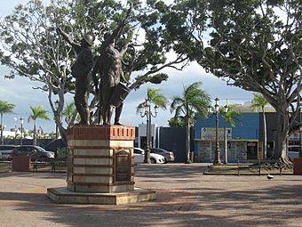
Another view of the plaza
-
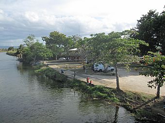
A view of the Río de la Plata river
-
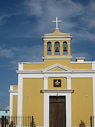
The San Antonio de Padua Catholic church


See also
 In Spanish: Dorado (Dorado) para niños
- List of communities in Puerto Rico
- List of barrios and sectors of Dorado, Puerto Rico
