Dotsero facts for kids
Quick facts for kids Dotsero |
|
|---|---|

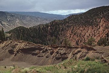
Dotsero maar in central Colorado near the junction of the Colorado and Eagle rivers.
|
|
| Highest point | |
| Elevation | 6,783 ft (2,067 m) |
| Geography | |
| Topo map | USGS Dotsero |
| Geology | |
| Age of rock | Holocene |
| Mountain type | maar |
| Last eruption | 2200 BCE ± 300 years |
|
Dotsero near the confluence of the Eagle and Colorado Rivers in Eagle County.
|
Dotsero is a special kind of volcano called a maar. It's located in Dotsero, Colorado. This volcano is about 700 meters (2,300 feet) wide and 400 meters (1,300 feet) deep. It sits near where the Colorado River and the Eagle River meet.
Scientists say Dotsero is a scoria cone. This means it's a small hill made of volcanic rock. It's also made of other materials like basalt (a type of volcanic rock) and sand. Dotsero erupted around 4,200 years ago. This makes it the youngest volcano in the state of Colorado.
Dotsero's Last Eruption
Dotsero is a Holocene volcano. This means it erupted during the most recent part of Earth's history. Its last eruption happened around 2220 BC, give or take 300 years.
When Dotsero erupted, it created small hills called scoria cones. These cones formed in a line on both sides of the main volcano. Scientists figured out the eruption date by using radiocarbon dating. They found wood buried under the volcanic rock and tested its age.
This eruption was one of the most recent in the continental United States. It created a large explosion crater. It also caused a lahar, which is a fast-moving mudflow made of volcanic ash and water. Plus, a lava flow stretched for about 3 kilometers (1.9 miles).
Is Dotsero Still Active?
Volcanoes that have erupted in the last 10,000 years are more likely to become active again. Dotsero falls into this group. The United States Geological Survey (USGS) keeps an eye on it. They think if Dotsero were to erupt again, it could affect air travel.
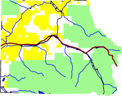
You can even see where the lava flowed! Interstate 70, a major highway, cuts right across the old lava flow.
 | Bayard Rustin |
 | Jeannette Carter |
 | Jeremiah A. Brown |


