Dougherty, Iowa facts for kids
Quick facts for kids
Dougherty, Iowa
|
|
|---|---|

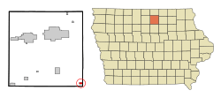
Location of Dougherty, Iowa
|
|
| Country | |
| State | |
| County | Cerro Gordo |
| Area | |
| • Total | 0.56 sq mi (1.45 km2) |
| • Land | 0.56 sq mi (1.45 km2) |
| • Water | 0.00 sq mi (0.00 km2) |
| Elevation | 1,102 ft (336 m) |
| Population
(2020)
|
|
| • Total | 62 |
| • Density | 110.52/sq mi (42.69/km2) |
| Time zone | UTC-6 (Central (CST)) |
| • Summer (DST) | UTC-5 (CDT) |
| ZIP code |
50433
|
| Area code(s) | 641 |
| FIPS code | 19-22080 |
| GNIS feature ID | 0455961 |
Dougherty is a small city located in Cerro Gordo County, Iowa, in the United States. It's a quiet place, home to a close-knit community. In 2020, the city had a population of 62 people. Dougherty is also part of the larger Mason City area.
Contents
A Look Back: Dougherty's History
Dougherty got its start and its name from a local farmer. A post office opened here in 1900. Some of the farmer's family members still live in the area today.
Where is Dougherty Located?
Dougherty is found in Iowa, at specific coordinates: 42.922381 degrees North and -93.041194 degrees West. This helps pinpoint its exact spot on a map.
The city covers a total area of about 0.55 square miles (1.45 square kilometers). All of this area is land, meaning there are no large bodies of water like lakes or rivers within the city limits.
Who Lives in Dougherty?
| Historical populations | ||
|---|---|---|
| Year | Pop. | ±% |
| 1910 | 171 | — |
| 1920 | 200 | +17.0% |
| 1930 | 215 | +7.5% |
| 1940 | 215 | +0.0% |
| 1950 | 212 | −1.4% |
| 1960 | 177 | −16.5% |
| 1970 | 133 | −24.9% |
| 1980 | 128 | −3.8% |
| 1990 | 107 | −16.4% |
| 2000 | 80 | −25.2% |
| 2010 | 58 | −27.5% |
| 2020 | 62 | +6.9% |
| Source: and Iowa Data Center Source: |
||
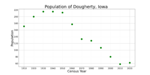
The population of Dougherty has changed over the years. You can see how it has grown and shrunk by looking at the numbers from past censuses.
Dougherty's Population in 2020
In 2020, a census counted 62 people living in Dougherty. These people lived in 34 different homes, and 26 of these were families. The city had about 110 people per square mile.
Most of the people in Dougherty were White (93.5%). A small number were Black or African American (4.8%). Some residents (6.5%) identified as Hispanic or Latino.
About half of the homes had children under 18 living there. The average age of people in Dougherty was about 45.8 years old. About 25.8% of residents were under 20. Many residents (38.7%) were between 45 and 64 years old.
Dougherty's Population in 2010
The 2010 census showed that 58 people lived in Dougherty. There were 29 homes in total. The population density was around 105 people per square mile.
Most of the people were White (96.6%), and a small number were Asian (3.4%).
About 10.3% of homes had children under 18. The average age in the city was 51.7 years. About 8.6% of residents were under 18. Many people (46.5%) were between 45 and 64 years old.
Learning in Dougherty: Schools
Students in Dougherty attend schools that are part of the West Fork Community School District. This school district was created in 2011. It was formed when two other school districts, SCMT and Rockwell-Swaledale, joined together.
Want to Learn More?
 In Spanish: Dougherty (Iowa) para niños


